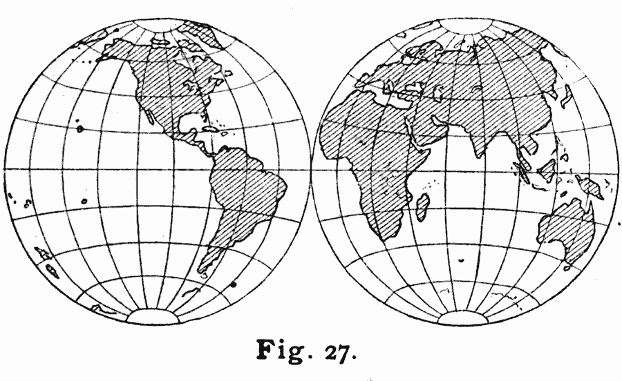
Description: A double hemisphere map of the world from 1909 showing the Lambert's Projection of the Eastern and Western hemispheres. "In Lambert's Projection (Fig. 27), equal areas on the map represent equal areas on the earth's surface. It may, therefore, be used when areas are to be compared. The equator and the central meridian (not drawn on Fig. 27) of each hemisphere are straight lines drawn at right angles, but the parallels and all other meridians are dissimilar curved lines, the bounding meridians of each hemisphere joining at the poles to form circles. The space between meridians decreases toward the boundary of each hemisphere, but that between parallels increases in such proportion that all the subdivisions between any two parallels have the same area." — Hinman, 1909, pp. 53–54.
Place Names: A Complete Map of Globes and Multi-continent, Africa, �Asia, �Australia, �Europe, �North America, �South Americ
ISO Topic Categories: location,
inlandWaters,
oceans
Keywords: Lambert's Projection of the World, kMapProjection, location,
inlandWaters,
oceans, Unknown, 1909
Source: Russell Hinman, Eclectic Physical Geography (Cincinnati, Ohio: Houghton Mifflin Company, 1888) 54
Map Credit: Courtesy the private collection of Roy Winkelman |
|