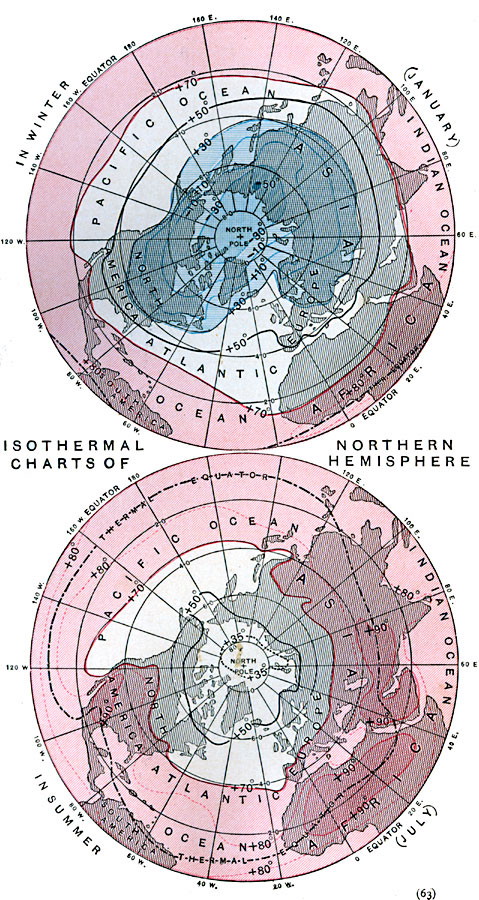
Description: A map from 1888 of the northern hemisphere showing areas of typical mean monthly temperatures in January and July. Isothermal lines, or isotherms, show areas with the same mean temperature. The regions in which the mean temperature is higher than 70° Fahrenheit are tinted pink, those in which it is lower than 30° Fahrenheit are tinted blue, while those having a temperature between 30° and 70° are untinted. The chart also shows the thermal equator (dashed line), the line along which the greatest heat on the earth's surface occurs. "As the sun is nearly vertical over the southern tropic in January, and over the northern tropic in July, it might be expected that during the year the thermal equator would travel backward and forward with the sun between these parallels. The different powers of land and water for accumulating and retaining heat, however, greatly modify its annual journey. In July the high temperature of the great land surfaces carries the thermal equator to between 20° and 30° north latitude over the continents, while, in consequence of the slower change of temperature of the water surfaces, it lies in the neighborhood of only 10° north latitude over the oceans. In January, the summer of the southern hemisphere, the influence of the larger land masses to the north is still great enough to hold the thermal equator very near the geographical equator in the southern hemisphere, while the western extensions of Africa and South America prevent it from crossing into the southern hemisphere at all in those regions." — Hinman, 1888, p. 64.
Place Names: Northern Hemisphere, Asia, �Europe, �North Americ
ISO Topic Categories: climatologyMeteorologyAtmosphere,
inlandWaters,
location,
oceans
Keywords: Seasonal Isothermal Charts of the Northern Hemisphere, physical, �meteorological, kClimate, physical features, climate,
temperature, climatologyMeteorologyAtmosphere,
inlandWaters,
location,
oceans, Unknown, 1888
Source: Russell Hinman, Eclectic Physical Geography (Cincinnati, Ohio: Houghton Mifflin Company, 1888) 63
Map Credit: Courtesy the private collection of Roy Winkelman |
|