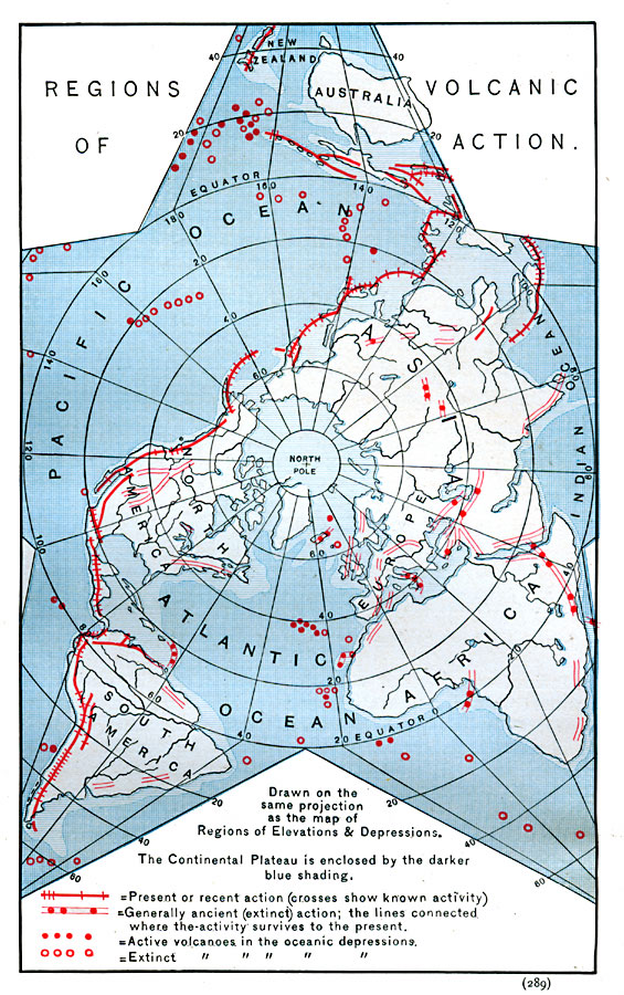
Description: A star-shaped world map on a Polar Projection from 1888 showing the regions of volcanic activity on the earth. Regions of surface activity are shown with solid red lines for present or recent activity (crosses show known activity) and open red lines for ancient or extinct activity. Submarine activity is shown with solid red dots for active volcanoes, and red circles for extinct volcanoes. The continental plateaus are shown in light blue, enclosed by darker blue shading. "The indications of past or present volcanic action are found in all latitudes and longitudes, and at all elevations. They occur on the continents, and on both the continental and oceanic islands, while several recorded submarine eruptions attest their occurrence upon the sea bottom. [...] About 300 volcanoes are known to be active. About one half of these occur on the continental islands lying south-east and east of Asia, and extending from New Zealand to Alaska. Within this region, volcanism is at present more energetic than elsewhere on the globe. About one fourth of the active volcanoes are distributed irregularly along the elevated western margin of the American main-land, from Alaska to the Str. of Magellan. [...] Thus, fully three fourths of all active volcanoes known lie just within the convex or generally rising border of the continental plateau." — Hinman, 1888, p. 288.
Place Names: A Complete Map of Globes and Multi-continent, Africa, �Asia, �Australia, �Europe, �North America, �South Americ
ISO Topic Categories: geoscientificInformation,
inlandWaters,
location,
oceans
Keywords: Regions of Volcanic Action, physical, physical features, geoscientificInformation,
inlandWaters,
location,
oceans, Unknown, 1888
Source: Russell Hinman, Eclectic Physical Geography (Cincinnati, Ohio: Houghton Mifflin Company, 1888) 289
Map Credit: Courtesy the private collection of Roy Winkelman |
|