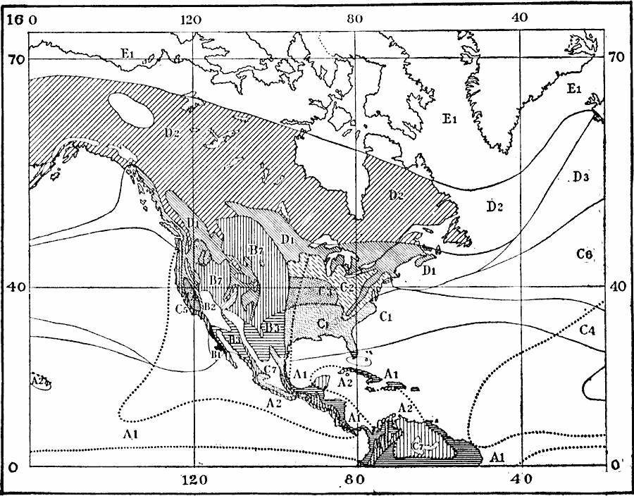
Description: A map from 1911 of the climate regions of North America using the classification system developed by Wladimir Köppen, based on the concept that native vegetation is the best expression of climate. The major groups are (A) tropical/megathermal climates, (B) dry (arid and semiarid) climates, (C) temperate/mesothermal climates, (D) continental/microthermal climates, and (E) polar climates. On this map, the major groups are further broken down as (A1) Liana, (A2) Baobab, (B1) Garva, (B2) Simoon, (B3) Mesquite, (B7) Prairie, (C2) Hickory, (C3) Corn, (C4) Olive, (C5) Heath, (C7) High Savanna, (D1) Oak, (D2) Birch, and (E1) Arctic Fox. Tracts enclosed by broken line have distinct dry seasons, with a rain probability of less than 0.20.
Place Names: A Complete Map of North America, Canada, �United States, �Mexico, �Cub
ISO Topic Categories: climatologyMeteorologyAtmosphere
Keywords: Köppen Climate Classification of North America, physical, �statistical, �meteorological, kClimate, physical features, vegetation, climate, climatologyMeteorologyAtmosphere, Unknown, 1911
Source: Isaiah Bowman, Ph. D., Forest Physiography (New York, NY: John Wiley and Sons, 1911) 111
Map Credit: Courtesy the private collection of Roy Winkelman |
|