This science ClipArt gallery offers 98 images of the science of hydrology, which is the study of water movement, distribution, and quality throughout Earth. This gallery contains images involving hydrology, including water movement and creation of atolls and barrier reefs, and water tables.
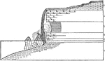
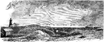
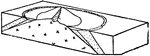
American Falls, Niagara
Section of the American Falls, Niagara. In front of the falls lie the larger blocks of Lockport dolomite,…
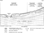
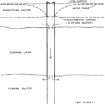
Upper Floridan Aquifer
"Generalized schematic of the hydrogeology of the study area. 1, unconfined conditions (Hawthorn Formation…
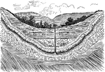
Artesian Conditions in Sulphur Spring Valley
Diagrammatic section showing artesian conditions in Sulphur Spring Valley.
Dakota Artesian System
East-west section across South Dakota to show the Dakota artesian system. The Dakota sandstone is composed…
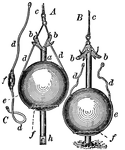
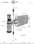
Artesian Well
Artesian Wells differ from ordinary wells in that their waters are discharged by natural pressures on…
Artesian Well
A boring in the ground through which currents of water rise from various depths toward or above the…
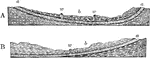
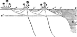
Artesian Well Conditions
"Diagrams illustrating the conditions favorable for artesian wells. In A, the porous bed a is in the…
Artesian Wells
An artesian well is a confined aquifer whose water is pressurized. Water will thus flow out of an artesian…
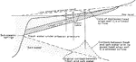
Atlantic Shelf
"Profile of the bottom of the Atlantic Ocean and adjoining land in New Jersey and Pennsylvania, showing…
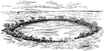
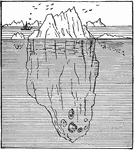
Atoll
"Atoll, a coral reef surrounding a pool of shallow water, usually called a lagoon. The atoll is formed…
Coral Island of Atoll
"Atolls. A coral island commonly consists of a narrow rim of reef, surrounding a lagoon." -Dana, 1880
Section of Coral Island of an Atoll
"represents a section of an island, from the ocean (o) to the lagoon (l). On the ocean side, from o…
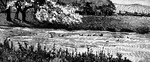
Barrier Beach
"Where the sea bottom has a very gentle slope, the waves break at some distance from the shore and the…
Bay-bar
A Bay-bar, with narrow inlet which leaves the water of the bay salty. South Shore of Marthas Vineyard.
Bay-bar
A Bay-bar completely cutting off a bay and converting it into a closed shore-pond. South Shore of Marthas…
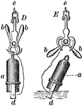
British Navy Sounding Apparatus
"To measure the depth of; fathom; try or test, as the depth of water and the quality of the ground,…
Brooke's Deep Sea Sounding Apparatus
"To measure the depth of; fathom; try or test, as the depth of water and the quality of the ground,…
Coastal Plain After Elevation
A coastal plain after elevation and renewed dissection. Two cuestas and two lowlands are now produced…
Coastal Plain After Peneplanation
A coastal plain after peneplanation. The strata are now beveled across by the peneplain, and the rivers…
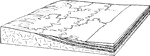
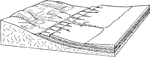
Coastal Plain Strata
Diagrammatic section of coastal plain strata in a transgressive or overlapping series.
Connecter Well
"Schematic sectional view of a connector well between nonartesian and Floridan aquifers." -Knochenmus,…
Contamination
"Diagram showing possible conditions of contamination of wells by sea water." -Gunter, 1933
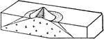
Coral Reef Section
A section of an actual coral reef, showing the formation: two sides tall, above sea level with the middle…
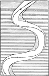
Current
Diagram showing the stronger meandering of the current as compared with the river as a whole.
Delta
Section of a small delta in a lake, showing the fore-sets of pebbles and sand, the bottom-sets of clay,…
First Cycle of Erosion
A coastal plain in the first cycle of erosion. The presence of two hard layers produces a terraced cuesta…
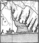
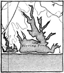
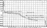
Florida Shore
Diagrammatic section of Florida along the line N.S. showing the relative position of the shore.
Groundwater Position
"Diagram illustrating the position of the groundwater surface (the dotted line) in a region of undulating…
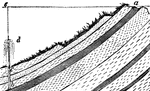
Groundwater Source
The diagram shows the source of groundwater: water falls into porous ground (a), flows underground to…
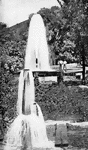
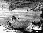
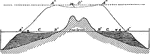
Horseshoe Falls, Niagara
Section of the Horseshoe Falls, Niagara, to show the depth of water below the falls and the arrangement…
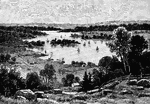
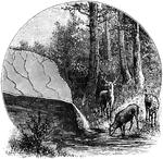
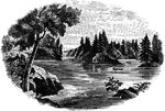
Lake and Vegetation
"Diagram illustrating the gradual filling up of lakes by the encroachment of vegetation, and also the…
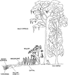
Lake Littoral Zone
"Section across a lake littoral zone, showing typical plant species." From left to right: tapegrass,…
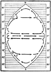
Ideal Ocean Circulation
Diagram showing the circulation in an ideal ocean extending from pole to pole and covering one fourth…
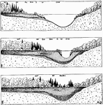
Offshore Bar
Diagram illustrating the development, migration, and complete destruction of an offshore bar and the…
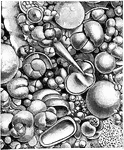
Ooze
"One third of the sea bottom is covered with a soft gray ooze or mud made up entirely of the shells…
Origin of Springs
A spring is a point where groundwater flows from the ground, and is thus where the aquifer surface meets…
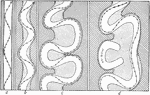
Barrier Reef Development
"Diagram suggesting the development of a barrier reef and an atoll, successively, from a fringing reef,…
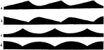
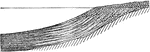
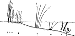
Ripple Marks
Diagram illustrating the forms of ripple marks and of the reverse impressions of the same.