This science ClipArt gallery offers 98 images of the science of hydrology, which is the study of water movement, distribution, and quality throughout Earth. This gallery contains images involving hydrology, including water movement and creation of atolls and barrier reefs, and water tables.

Section of the American Falls, Niagara. In front of the falls lie the larger blocks of Lockport dolomite, broken from the edge of the falls.

American Falls, Niagara

Section of the American Falls, Niagara. In front of the falls lie the larger blocks of Lockport dolomite,…
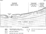
"Generalized schematic of the hydrogeology of the study area. 1, unconfined conditions (Hawthorn Formation absent or very thin); 2, semiconfined conditions (Hawthorn Formation less than 100 feet thick); 3, confined conditions (Hawthorn Formation greater than 100 feet thick)." -Hatzell, 1995

Upper Floridan Aquifer

"Generalized schematic of the hydrogeology of the study area. 1, unconfined conditions (Hawthorn Formation…

Diagrammatic section showing artesian conditions in Sulphur Spring Valley.

Artesian Conditions in Sulphur Spring Valley

Diagrammatic section showing artesian conditions in Sulphur Spring Valley.

East-west section across South Dakota to show the Dakota artesian system. The Dakota sandstone is composed for the most part of well-rounded and well-assorted quartz grains, representing an ancient river and wind-formed sand deposit.

Dakota Artesian System

East-west section across South Dakota to show the Dakota artesian system. The Dakota sandstone is composed…
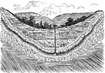
Artesian Wells differ from ordinary wells in that their waters are discharged by natural pressures on their reservoirs, so that pumping is not necessary to raise the water Such wells are therefore true springs.

Artesian Well

Artesian Wells differ from ordinary wells in that their waters are discharged by natural pressures on…

A boring in the ground through which currents of water rise from various depths toward or above the surface.

Artesian Well

A boring in the ground through which currents of water rise from various depths toward or above the…

"Diagrams illustrating the conditions favorable for artesian wells. In A, the porous bed a is in the form of a basin; in B, it merely dips." -Salisbury, 1919

Artesian Well Conditions

"Diagrams illustrating the conditions favorable for artesian wells. In A, the porous bed a is in the…

An artesian well is a confined aquifer whose water is pressurized. Water will thus flow out of an artesian well without pumping.

Artesian Wells

An artesian well is a confined aquifer whose water is pressurized. Water will thus flow out of an artesian…

"Profile of the bottom of the Atlantic Ocean and adjoining land in New Jersey and Pennsylvania, showing the continental shelf." -Gilbert, 1910

Atlantic Shelf

"Profile of the bottom of the Atlantic Ocean and adjoining land in New Jersey and Pennsylvania, showing…

"Atoll, a coral reef surrounding a pool of shallow water, usually called a lagoon. The atoll is formed by the building of a coral reef on a circular or nearly circular foundation. It is usually broken in one or more places so that the lagoon is connected with the surrounding waters." -Foster, 1921

Atoll

"Atoll, a coral reef surrounding a pool of shallow water, usually called a lagoon. The atoll is formed…

"Atolls. A coral island commonly consists of a narrow rim of reef, surrounding a lagoon." -Dana, 1880

Coral Island of Atoll

"Atolls. A coral island commonly consists of a narrow rim of reef, surrounding a lagoon." -Dana, 1880

"represents a section of an island, from the ocean (o) to the lagoon (l). On the ocean side, from o to a, there is shallow water for some distance out; and where not too deep, the bottom is covered here and there with growing corals. Between a and b there is a platform of coral rock, mostly bare at low tide, but covered at high ... b to d is the wooded portion of the island. The whole width (is) from the beach (b) to the lagoon (c)." -Dana, 1880

Section of Coral Island of an Atoll

"represents a section of an island, from the ocean (o) to the lagoon (l). On the ocean side, from o…

"Where the sea bottom has a very gentle slope, the waves break at some distance from the shore and the sand they carry is deposited, forming a barrier beach (B) along the line of greatest disturbance. The strip of water inclosed between the land and the barrier beach is called a lagoon (L)." -Dryer, 1901

Barrier Beach

"Where the sea bottom has a very gentle slope, the waves break at some distance from the shore and the…
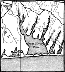
Section of a barrier reef.

Barrier Section

Section of a barrier reef.

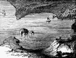
An image of a bay.

Bay

An image of a bay.

A Bay-bar, with narrow inlet which leaves the water of the bay salty. South Shore of Marthas Vineyard.
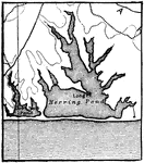
Bay-bar

A Bay-bar, with narrow inlet which leaves the water of the bay salty. South Shore of Marthas Vineyard.

A Bay-bar completely cutting off a bay and converting it into a closed shore-pond. South Shore of Marthas Vineyard

Bay-bar

A Bay-bar completely cutting off a bay and converting it into a closed shore-pond. South Shore of Marthas…
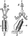
The cross-section of a beach.

Beach

The cross-section of a beach.

An illustration looking seaward from a country road near Mobile, Alabama.

Beach

An illustration looking seaward from a country road near Mobile, Alabama.

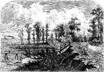
An illustration of the South Carolina coast near Fort Sumter.

Beach

An illustration of the South Carolina coast near Fort Sumter.

"To measure the depth of; fathom; try or test, as the depth of water and the quality of the ground, by sinking a plummet or lead attached to a line on which is marked the number of fathoms...a, lead; b, counterpoised hooks which engage the loop at the top of the lead; d, wedge-shaped cup for specimens, attached by cord or wire to the pivot of the hooks; e, attachment for the sounding-line or wire. When the cup d touches bottom, the hooks b drop into the position show in E; the sinker or lead then drops over, releasing the cup, and this, with its specimen and the hooks, is drawn to the surface." —Whitney, 1889

British Navy Sounding Apparatus

"To measure the depth of; fathom; try or test, as the depth of water and the quality of the ground,…
A running brook.

Brook

A running brook.

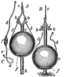
"To measure the depth of; fathom; try or test, as the depth of water and the quality of the ground, by sinking a plummet or lead attached to a line on which is marked the number of fathoms...a, rod with horns b pivoted thereto; c, sounding-line; d, wires by which the lead e is attached to the horns, connected with a washer f under the lead; h, opening in lower end of rod, by which specimens of the bottom may be secured. When the rod strikes the bottom, the lead slides downward, bringing the horns into the position shown in B, and releasing the wires d and the lead; the rod only is then drawn up, leaving the lead at the bottom." —Whitney, 1889

Brooke's Deep Sea Sounding Apparatus

"To measure the depth of; fathom; try or test, as the depth of water and the quality of the ground,…

A coastal plain after elevation and renewed dissection. Two cuestas and two lowlands are now produced from the hard and weak strata, respectively.

Coastal Plain After Elevation

A coastal plain after elevation and renewed dissection. Two cuestas and two lowlands are now produced…

A coastal plain after peneplanation. The strata are now beveled across by the peneplain, and the rivers are no longer controlled by the topography.

Coastal Plain After Peneplanation

A coastal plain after peneplanation. The strata are now beveled across by the peneplain, and the rivers…

Diagrammatic section of coastal plain strata in a transgressive or overlapping series.

Coastal Plain Strata

Diagrammatic section of coastal plain strata in a transgressive or overlapping series.
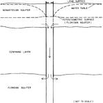
"Schematic sectional view of a connector well between nonartesian and Floridan aquifers." -Knochenmus, 1975

Connecter Well

"Schematic sectional view of a connector well between nonartesian and Floridan aquifers." -Knochenmus,…

"Diagram showing possible conditions of contamination of wells by sea water." -Gunter, 1933

Contamination

"Diagram showing possible conditions of contamination of wells by sea water." -Gunter, 1933

A coral island developed from a submerged volcano or other rock.

Coral Island

A coral island developed from a submerged volcano or other rock.

A section of an actual coral reef, showing the formation: two sides tall, above sea level with the middle lower and submerged.

Coral Reef Section

A section of an actual coral reef, showing the formation: two sides tall, above sea level with the middle…

Diagram showing the stronger meandering of the current as compared with the river as a whole.

Current

Diagram showing the stronger meandering of the current as compared with the river as a whole.

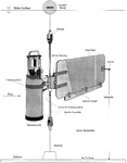
"Typical deployment of tidal velocity current meter." -Goodwin, 1996

Current Meter

"Typical deployment of tidal velocity current meter." -Goodwin, 1996

Section of a small delta in a lake, showing the fore-sets of pebbles and sand, the bottom-sets of clay, and the top-sets of coarse sand and pebbles.

Delta

Section of a small delta in a lake, showing the fore-sets of pebbles and sand, the bottom-sets of clay,…

"Generalized profile of the earth-crust." -Dryer, 1901

Earth Crust

"Generalized profile of the earth-crust." -Dryer, 1901

A coastal plain in the first cycle of erosion. The presence of two hard layers produces a terraced cuesta front. In exceptional cases the upper terrace may weather back with sufficient rapidity to constitute a second cuesta with a lowland of some width between it and the lower cuesta, if the weak stratum between the harder is of sufficient thickness.

First Cycle of Erosion

A coastal plain in the first cycle of erosion. The presence of two hard layers produces a terraced cuesta…

Diagrammatic section of Florida along the line N.S. showing the relative position of the shore.

Florida Shore

Diagrammatic section of Florida along the line N.S. showing the relative position of the shore.

"Diagram illustrating the position of the groundwater surface (the dotted line) in a region of undulating topography." -Salisbury, 1919

Groundwater Position

"Diagram illustrating the position of the groundwater surface (the dotted line) in a region of undulating…

The diagram shows the source of groundwater: water falls into porous ground (a), flows underground to be brought to the surface in another location.

Groundwater Source

The diagram shows the source of groundwater: water falls into porous ground (a), flows underground to…
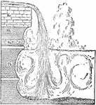
Section of the Horseshoe Falls, Niagara, to show the depth of water below the falls and the arrangement of the strata.

Horseshoe Falls, Niagara

Section of the Horseshoe Falls, Niagara, to show the depth of water below the falls and the arrangement…
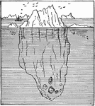
Floating iceburg, showing the proportion of visible to submerged ice.

Iceburg

Floating iceburg, showing the proportion of visible to submerged ice.

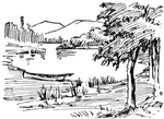
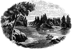
Lake with trees and mountains in distance.

Lake

Lake with trees and mountains in distance.

An image of a lake in a town.

Lake

An image of a lake in a town.

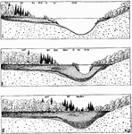
"Diagram illustrating the gradual filling up of lakes by the encroachment of vegetation, and also the stages in the origin of peat and marl deposits in lakes. The several plant associations of the Bog series, displacing one another, belong to the following major groups: (I) O. W., open water succession; (2) M., marginal succession; (3) S., shore succession; (4) B., bog succession, comprising the bog-meadow (Bm), bog-shrub (Bs) and bog-forest (Bf); and (5) M. F., mesophytic forest succession." -Gager, 1916

Lake and Vegetation

"Diagram illustrating the gradual filling up of lakes by the encroachment of vegetation, and also the…
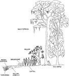
"Section across a lake littoral zone, showing typical plant species." From left to right: tapegrass, yellow cow lily, maidencane, cattail, willow, bald cypress, and red maple. -Phelps, 1995

Lake Littoral Zone

"Section across a lake littoral zone, showing typical plant species." From left to right: tapegrass,…
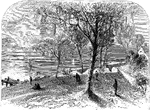
An illustration of a lake scene with people walking.

Lake Scene

An illustration of a lake scene with people walking.

A boy by a marsh.

Marsh

A boy by a marsh.

Diagram illustrating the development of meanders in a river.

Meanders of River

Diagram illustrating the development of meanders in a river.

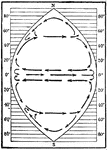
Diagram showing the circulation in an ideal ocean extending from pole to pole and covering one fourth the circumference of the earth.

Ideal Ocean Circulation

Diagram showing the circulation in an ideal ocean extending from pole to pole and covering one fourth…

Diagram illustrating the development, migration, and complete destruction of an offshore bar and the lagoon deposits behind it.

Offshore Bar

Diagram illustrating the development, migration, and complete destruction of an offshore bar and the…
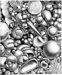
"One third of the sea bottom is covered with a soft gray ooze or mud made up entirely of the shells of minute animals which live in the surface waters."

Ooze

"One third of the sea bottom is covered with a soft gray ooze or mud made up entirely of the shells…
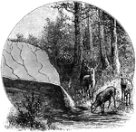
A spring is a point where groundwater flows from the ground, and is thus where the aquifer surface meets the ground surface

Origin of Springs

A spring is a point where groundwater flows from the ground, and is thus where the aquifer surface meets…

Diagram of plant zones in small lake near Merryman's Lake, Michigan.

Plant Zones

Diagram of plant zones in small lake near Merryman's Lake, Michigan.

Diagram showing how plants fill ponds from the sides and top.

Pond Diagram

Diagram showing how plants fill ponds from the sides and top.

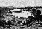
River with two boats on it. Scenery that of the north east.

Portait of a River

River with two boats on it. Scenery that of the north east.

"Diagram suggesting the development of a barrier reef and an atoll, successively, from a fringing reef, by sinking. 1, Fringing reef, formed in shallow water; 2, barrier reef, developed from fringing reef after subsidence; 3, the atoll which succeeds the barrier reef." -Salisbury, 1919

Barrier Reef Development

"Diagram suggesting the development of a barrier reef and an atoll, successively, from a fringing reef,…

A barrier reef is a coral reef that is far from land.

Barrier Reef

A barrier reef is a coral reef that is far from land.

Diagram illustrating the conversion of a fringing into a barrier reef by subsidence.

Barrier Reef

Diagram illustrating the conversion of a fringing into a barrier reef by subsidence.

Diagram illustrating the conversion of a barrier reef into an atoll.

Barrier Reef

Diagram illustrating the conversion of a barrier reef into an atoll.

A fringing reef is a coral reef that is close to land.

Fringing Reef

A fringing reef is a coral reef that is close to land.

Diagram illustrating the forms of ripple marks and of the reverse impressions of the same.
Ripple Marks

Diagram illustrating the forms of ripple marks and of the reverse impressions of the same.