Clipart tagged: ‘geology diagram’

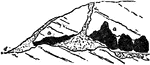
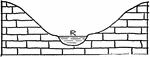
Limestone Cavern
"Section of a Limestone Cavern...A limestone hill, perforated by a cavern (b b) which communicates with…
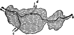
Limestone Cavern
"Section of a Limestone Cavern with fallen-in roof and concealed entrance." -Geikie, 1893

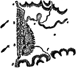
Lake
"Plan of a lake entered by three streams (c, d, e), each of which deposits a cone of sediment (a, b)…
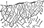
Relief Features
A diagram of the relief features: mountain, plateau, plain, ocean basin, ocean deep, and volcano.
River Channel
"A broad, shallow river channel" that would flow slower than a deeper, narrower channel. -Salisbury,…
River Channel
A deep, narrow river channel that would flow faster than a broader, shallower channel.
Deep-Seated Springs
"Deep-seated Springs (s, s') rising through joints at a fault (f)." -Geikie, 1893
Simple Springs
Simple or surface springs: (d) stratum, (e) clay, (c) pervious bed, (a) strata, (b) valley.
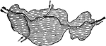
Streamlet
"Streamlet (b) entering a small lake (a), and depositing a fan of sediment (c)." -Geikie, 1893
Streamlet
"Streamlet (b) entering a small lake (a), and depositing a fan of sediment (c)." -Geikie, 1893
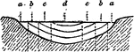
Valley
"Diagram of a valley, the top of which is ten times the width of the stream." -Salisbury, 1919
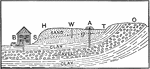
Underground Waters
The image shows different layers of clay, gravel, and sand and how underground waters travel through.…