The Bluffs ClipArt gallery offers 12 views of clips that overlook a body of water or plain.

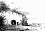
A bluff with broken stones at its base.

Bluff

A bluff with broken stones at its base.

"Drury's Bluff, a Confederate position on the James River, near Richmond, Va. The principal Confederate defense of Richmond was Fort Darling, a heavy work on a high bank called Drury's Bluff, eight miles below Richmond. Here the river was closed with heavy piling and vessels loaded with stone sunk in the channel. The work was casemated and mounted with heavy guns. It will be remembered that the Federal ironclads, the <em>Galena</em> and the <em>Monitor</em>, were repulsed here during the progress of the Peninsular campaign. The <em>Monitor</em> was unable to elevate her guns sufficiently to reach the works, and the sides of the <em>Galena</em> were not thick enough to resist the plunging shot from the fort, which struck its sides at right angles. The <em>Naugatuck</em>, the only other vessel engaged in the assault, burst her single gun on the second discharge."— Frank Leslie, 1896

Drury's Bluff

"Drury's Bluff, a Confederate position on the James River, near Richmond, Va. The principal Confederate…
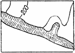
The typical representation of bluffs (other than rocky) on a topographical map.

Bluffs, Other than Rocky

The typical representation of bluffs (other than rocky) on a topographical map.

The typical representation of rocky bluffs on a topographical map.

Rocky Bluffs

The typical representation of rocky bluffs on a topographical map.

"Camp Dennison, sixteen miles above Cincinnati, on the banks of the Miami River, General Cox commanding- the Cleveland, Cincinnati and Columbus Railroad passed directly through the camp grounds. This camp, which was organized for a camp of instruction and drill, was situated about sixteen miles above Cincinnati, on a field of seventy-five acres, on the banks of the Miami River, surrounded by high bluffs. The Cleveland, Cincinnati and Columbus Railroad passed directly through the grounds, and this road was guarded for miles by sentries in order to watch bridges, telegraph wires and culverts, as spies were infesting the whole country. There were 18,000 men in camp, including the splendid Kentucky Regiment of Guthrie Grays, and quarters were erected for 20,000 men, who were soon on the ground. The tents were rough-board shanties, but were comfortable, and the officers had marquees erected in the rear of the regimental quarters. This brigade was under the command of General Cox, a West Point officer, and under the immediate supvervision of General George B. McClellan. It was in a beautiful location, and the troops were kept under a very strict surveillance, there being but few spectators allowed to visit the ground." — Frank Leslie, 1896

Camp Dennison

"Camp Dennison, sixteen miles above Cincinnati, on the banks of the Miami River, General Cox commanding-…

"General view of Columbus, Ky., and its fortications, looking down the river, showing the 'Iron Bluffs' crowned with batteries, the water batteries and the arrival of the Federal gunboats, March 4th, 1862. Our sketch of Columbus and its fortifications, which was called the Western Gibraltar by the Confederates, became untenable by them after the fall of Fort Henry, Donelson, Bowling Green, and especially Nashville. A glance at our illustration will show its immense strength on the river side, and it must be confessed that General Polk had not been slow to improve its natural advantages. The water batteries entirely command the river, and to silence them would have required all Commodore Foote's gallantry and skill. Our picture represents all the water batteries which are situated about a mile above the City of Columbus. The bluffs which are also crowned with cannon, are from seventy to eighty feet high."— Frank Leslie, 1896

Columbus, Kentucky

"General view of Columbus, Ky., and its fortications, looking down the river, showing the 'Iron Bluffs'…

"Cornwallis' Cave, the excavation in the marl bluff."—Lossing, 1851

Cornwallis' Cave

"Cornwallis' Cave, the excavation in the marl bluff."—Lossing, 1851

This illustration shows a jointed structure. In this drawing, there are two systems of joints or divisional planes in the same region, crossing one another, and the undermining of a bluff of jointed beds and tumbling down of masses leads to the production of forms like those of fortifications or broken walls.

Jointed Rock

This illustration shows a jointed structure. In this drawing, there are two systems of joints or divisional…
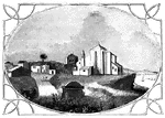
View of Palos. The pile of buildings in this view, standing upon the bluff, is the ancient Church of St. George.

Palos

View of Palos. The pile of buildings in this view, standing upon the bluff, is the ancient Church of…
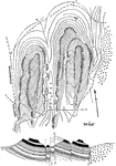
"Map and section of trap ridges near Woodbury. The topography is indicated by sketched contours, with hachures for trap bluffs. The lower sandstone slopes are all covered, and the northern bluff of the western group of ridges is quite buried in drift. The crystalline rocks appear on the east. The section suggests an interpretation of the surface forms." -Walcott, 1901

Trap Ridges

"Map and section of trap ridges near Woodbury. The topography is indicated by sketched contours, with…
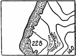
The Trenton gravel bluff in New Jersey.

Trenton Bluff

The Trenton gravel bluff in New Jersey.

Section of bluff two miles south of Trenton, New Jersey.

Trenton Bluff

Section of bluff two miles south of Trenton, New Jersey.