|
|
|
| Maps > Astronomical > Solar System |
A collection of maps of the Solar System and Planetary Earth maps.
|
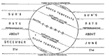
Sun's Rays and Temperature Zones during the Solstices,
1901 |
|
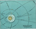
Solar System,
1920 |

|
Comparative Sizes of the Planets,
1920 |
|
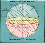
Apparent Path of the Sun,
1920 |
|
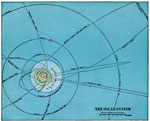
Solar System,
1920 |

|
Comparative Sizes of the Planets,
1920 |
| First | Previous |
| Maps > Astronomical > Solar System |
Maps ETC is a part of the Educational Technology Clearinghouse
Produced by the Florida Center for Instructional Technology © 2009
College of Education, University of South Florida