Maps Site map
  Maps > United States > Early America 1400-1800
Site Map  

  Record   131   to   140  of   143

A collection of historic maps of early America from explorations and settlements of the English, French, and Spanish, to the end of the American Revolutionary War.

Washington's Campaigns, 1776–1778
A map of New Jersey and Pennsylvania showing the campaigns of General George Washington in the area between 1776 and 1778. The map is keyed to show the route of Washington's March from New York to Trenton and back through Princeton to Morristown (177...

The Hudson, 1776–1783
A map of the Hudson River area from West Point to the Long Island Sound showing the Revolutionary War posts along the river, including West Point, Peekskill, Verplanck's Point, Stony Point, New York, Brooklyn, and the forts Montgomery, Clinton, Indep...

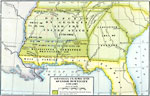
Georgia Claims and Spanish Boundary, 1776–1802
A map of Georgia and Spanish Florida showing the boundaries established and territorial disputes between 1776 and 1802. The map shows the undisputed territory on the Atlantic, the disputed territory by Georgia and the United States between the Chatta...

Fort Herkimer, 1776–1832
A plan of Fort Herkimer on the Mohawk River, originally built during the French and Indian War, and rebuilt during the American Revolutionary War (1776, renamed Fort Dayton). The fort was destroyed during the building of the Erie Canal (1832). Explan...

Victory of Americans, 1777
Map shows the victory of Americans at Saratoga in 1777. ...

The War in Northern New York, 1777
A map of the Adirondack Mountains, southern Lake Champlain, eastern Lake Ontario, and Hudson River Valley south to Peekskill showing the important battle sites of the area during the American Revolutionary War....

Seat of War in New Jersey, 1777
A map of New Jersey showing the routes of Washington to Trenton in 1776 from the Battle of Long Island and the route of British commander Clinton to Monmouth and New York after the capture of Philadelphia in 1777....

Philadelphia and Vicinity, 1777
A map of Philadelphia and vicinity in 1777 during the capture of the city by British Major General William Howe. The map shows the route of Howe's Philadelphia Campaign from Elkton to Chad's Ford, site of the Battle of Brandywine against Washington, ...

Burgoyne's Campaign, 1777
A map of the area of General John Burgoyne's Campaign in 1777, also known as the Saratoga Campaign, a series of battles between the British and Americans for control of the Hudson River Valley. The map shows the area from southern Lake Champlain to A...

Battle at the Brandywine, 1777
A map of the area in Pennsylvania south of Philadelphia detailing the Battle of Brandywine during the American Revolution (September 11, 1777). The map shows the battle site of Chad's Ford, the Lancaster Road, the British and American positions, the ...

First Previous Next Last


  Maps > United States > Early America 1400-1800
Site Map  

Maps ETC is a part of the Educational Technology Clearinghouse
Produced by the Florida Center for Instructional Technology © 2009
College of Education, University of South Florida