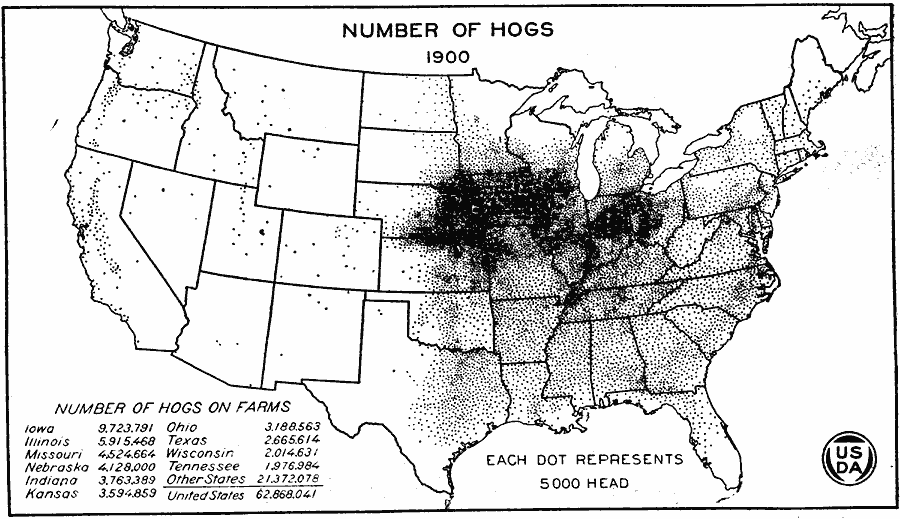
Description: A map of the United States from the U. S. Department of Agriculture (1923) showing the numbers and location of hogs produced in the United States in 1900. "The most notable increases between 1880 and 1900 were made in Nebraska and Kansas and along the northern border of the Corn Belt in Wisconsin, northern Iowa, southern Minnesota, and southeastern South Dakota. Oklahoma and Indian Territory had been opened to settlement and many hogs were being produced in these new States." — United States Department of Agriculture Yearbook, 1923.
Place Names: Agriculture, Iowa, Illinois, Missouri, Nebraska, Indiana, Kansas, Ohio, Texas, Wisconsin, Tennessee, �hog
ISO Topic Categories: boundaries,
inlandWaters,
oceans,
farming
Keywords: United States Production of Hogs, physical, �political, �statistical, �production of hogs by united states in 1900, swine, pigs, pork, kAgriculture, physical features, country borders,
major political subdivisions, agriculture, boundaries,
inlandWaters,
oceans,
farming, Unknown, 1900
Source: , United States Department of Agriculture Yearbook 1922 (Washington, DC: Government Printing Office, 1923) 190
Map Credit: Courtesy the private collection of Roy Winkelman |
|