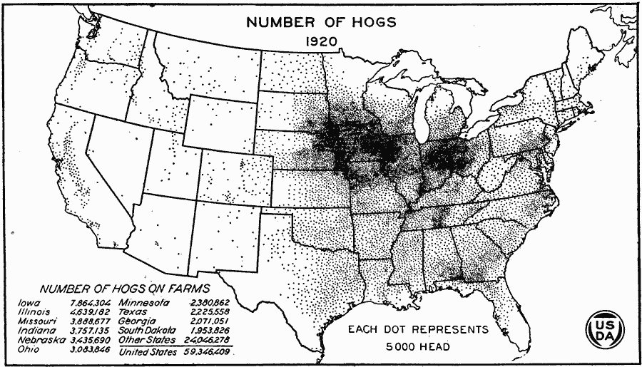
Description: A map of the United States from the U. S. Department of Agriculture (1923) showing the numbers and location of hogs produced in the United States in 1920. "Between 1910 and 1920 the number of hogs continued to increase in the Dakotas, but decreased notably in Kansas and Oklahoma, where war–time prices for wheat had caused it to supplant much of corn. In the western States, especially California, the number had increased; also in Alabama, Georgia, and the Carolinas." — United States Department of Agriculture Yearbook, 1923.
Place Names: Agriculture, Iowa, Illinois, Missouri, Indiana, Nebraska, Ohio, Minnesota, Texas, Georgia, South Dakota, �hog
ISO Topic Categories: boundaries,
inlandWaters,
oceans,
farming
Keywords: United States Production of Hogs, physical, �political, �statistical, �production of hogs by united states in 1920, swine, pigs, pork, kAgriculture, physical features, country borders,
major political subdivisions, agriculture, boundaries,
inlandWaters,
oceans,
farming, Unknown, 1920
Source: , United States Department of Agriculture Yearbook 1922 (Washington, DC: Government Printing Office, 1923) 191
Map Credit: Courtesy the private collection of Roy Winkelman |
|