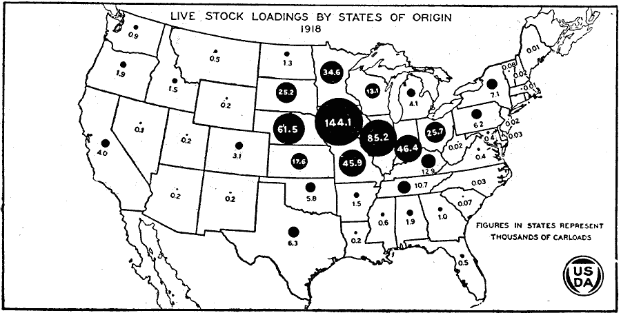
Description: A map of the United States from the U. S. Department of Agriculture (1922) showing the number of livestock loadings by state of origin in 1918. "In 1918 Iowa led in number of hogs loaded, with 144,105 cars; Illinois was second with 85,162 cars; Nebraska third with 61,489 cars; Indiana fourth with 46,362 cars, and Missouri fifth with 45,860 cars. Iowa loaded more than 25 per cent of all the hogs shipped during that year, whereas Missouri which was the fifth, loaded 8 per cent of the total." — United States Department of Agriculture Yearbook 1922, 1923.
Place Names: Agriculture, Iowa, Illinois, Nebraska, Indiana, Missouri, �hog
ISO Topic Categories: boundaries,
inlandWaters,
oceans,
farming,
economy
Keywords: Live Stock Loadings by States of Origin, physical, �political, �statistical, �live stock loadings by states of origin, livestock, kAgriculture, physical features, country borders,
major political subdivisions, agriculture, boundaries,
inlandWaters,
oceans,
farming,
economy, Unknown, 1918
Source: , United States Department of Agriculture Yearbook 1922 (Washington, DC: Government Printing Office, 1923) 231
Map Credit: Courtesy the private collection of Roy Winkelman |
|