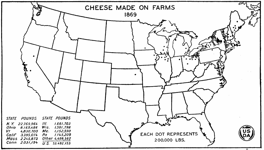
Description: A map of the United States from the U. S. Department of Agriculture (1922) showing the distribution of cheese made on farms by state in 1869. "The farm production of cheese in 1869 was only half that of 1859. Cheese production had increased, but two–thirds of the product was prepared in factories which are not represented on this map. Farm production continued to be important in western New England, central New York and northeastern Ohio." — United States Department of Agriculture Yearbook 1922, 1923.
Place Names: Agriculture, New York, Ohio, Vermont, California, Massachusetts, Connecticut, Illinois, Wisconsin, Maine, Pennsylvania, �chees
ISO Topic Categories: boundaries,
inlandWaters,
farming,
economy
Keywords: Cheese Made on Farms, physical, �political, �statistical, �cheese made on farms, cheese production by state, kAgriculture, physical features, country borders,
major political subdivisions, agriculture,
economic, boundaries,
inlandWaters,
farming,
economy, Unknown, 1869
Source: , United States Department of Agriculture Yearbook 1922 (Washington, DC: Government Printing Office, 1923) 308
Map Credit: Courtesy the private collection of Roy Winkelman |
|