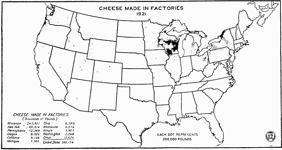
Description: A map of the United States from the U. S. Department of Agriculture (1922) showing the distribution of factory–produced cheese production by state in 1921. "Practically all the cheese is now made in factories, only 6,000,000 pounds in 1919, or less than 2 per cent of the total production of the United States, being made on farms. About two–thirds of the cheese is made in Wisconsin, and half of the remainder in New York. Cheese production has developed in those parts of Wisconsin and New York having less than 150 days in the growing season, except along the lake shores, and in the central, sandy portion of Wisconsin, which has poor pastures. The short, cool season favors summer pasture and cheese production, just as silage, winter dairying, butter making, skim milk, hogs, and corn complete the economic cycle in the warmer belt to the South." — United States Department of Agriculture Yearbook 1922, 1923.
Place Names: Agriculture, Wisconsin, New York, Pennsylvania, Oregon, California, Michigan, Ohio, Minnesota, Illinois, Washington, �chees
ISO Topic Categories: farming,
boundaries,
economy,
inlandWaters
Keywords: Cheese Made in Factories, physical, �political, �statistical, �factory made cheese production by state, kAgriculture, physical features, country borders,
major political subdivisions, agriculture, farming,
boundaries,
economy,
inlandWaters, Unknown, 1921
Source: , United States Department of Agriculture Yearbook 1922 (Washington, DC: Government Printing Office, 1923) 311
Map Credit: Courtesy the private collection of Roy Winkelman |
|