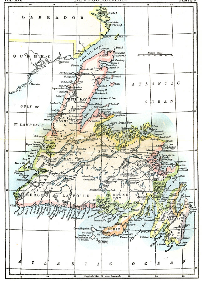
Description: A map from 1903 of the Canadian province of Newfoundland, showing cities, towns and ports, railways, lakes, rivers, and coastal features, as well as the coastal districts of White Bay, Bonne Bay, Bay of Exploits, Bonavista Bay, St. George's Bay, Burgeo, La Poile, Fortune Bay, Burin, Trinity Bay, Placienta, St. Mary's, Conception Bay, and Ferryland. "This island, which is a British colony, lies off the eastern coast of North America, directly across the Gulf of St. Lawrence. Its south-western extremity approaches within 50 miles of Cape Breton, while its most easterly projection is only 1640 miles from Valentia, on the coast of Ireland. It is situated between 46° 36’ 50" and 51° 39’ N. lat., and between 52° 37’ and 59° 24’ 50" W. long. Its greatest length, from Cape Ray to Cape Norman, is 317 miles; its greatest breadth, from Cape Spear to Cape Anguille, 316 miles; and the total area about 42,000 square miles. Its figure roughly approaches an equilateral triangle. Two large peninsulas project from the main body of the island. One of these (Petit Nord) points northwards, and is long and narrow. The other is the peninsula of Avalon, pointing south-east, and almost severed from the principal portion of the island, the connection being a narrow isthmus, in one place but 3 miles in width. On the eastern side of the Avalon peninsula is situated St. John's, the capital. Owing to its extensive frontage on the Atlantic, its numerous good harbours and its proximity to the Banks and the smaller fishing grounds, Avalon is the most thickly populated and commercially important part of the island." —Kellogg, 1903.
Place Names: Canada, Newfoundland, �Atlantic Ocean, �Gulf of St. Lawrence, �White Bay, �Notre Dame Bay, �Trinity Bay, �Fortune Bay, �Placentia Bay, �Belle Isle Strai
ISO Topic Categories: boundaries,
inlandWaters,
oceans
Keywords: Newfoundland, physical, �political, physical features,
topographical, major political subdivisions, boundaries,
inlandWaters,
oceans, Unknown,1903
Source: Day Otis Kellogg, Encyclopædia Britannica Vol. XVII (New York, NY: Werner Company, 1903) 384
Map Credit: Courtesy the private collection of Roy Winkelman |
|