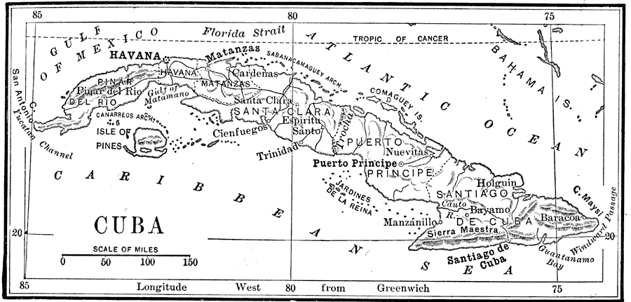
Description: A map from 1898 of Cuba: "the largest island of the West Indies. It is 720 miles long and averages 80 miles wide, and it has an area of 46,000 square miles. The surface, which is for the most part low and undulating, is broken by three distinct mountain ranges, the highest rising to an altitude of more than 7,000 feet. The eastern part of the island is more rugged and mountainous than the western, Nearly every part is well–drained by numerous water courses. [...] The mercury ranges from 50° in winter to 100° in summer, and the average temperature the year round is about 77°. The prevailing northeast winds bring an abundant rainfall, two thirds of which occurs in the summer [...] The soil is of exhaustless fertility. Nearly one half of the island has been cultivated or used for pasturage; the other half is covered with forests. The chief industries are the cultivation of sugar cane and tobacco. Coffee and bananas are produced in large quantities, and oranges and garden vegetables are grown for home consumption. Fine cattle and stout Cuban ponies are bred in the central and eastern districts. In the forests are many kinds of valuable trees-palm, mahogany, ebony, cedar, and, in the west, pines. [...] Iron ore, manganese, and copper have been mined near Santiago; and asphaltum exists abundantly at Cardenas." — Redway, 1898.
Place Names: Cuba, Havana, �Pinar Del Rio, �Santa Clara, �Nuevitas, �Santiago De Cuba, �Manzanillo, �Gulf of Mexico, �San Antonio, �Yucatan Channel, �Isle of Pines, �Canarreos Arch, �Gulf of Matamano, �Matanzas,�Cardenas, �Florida Strait, �Sabanacamaguey Arch, �Comaguey
ISO Topic Categories: boundaries,
elevation,
inlandWaters,
oceans,
transportation
Keywords: Cuba, physical, �political, �transportation, �historical, physical features,
topographical, country borders, roads,
railroads,
water routes, boundaries,
elevation,
inlandWaters,
oceans,
transportation, Unknown,1898
Source: Jacques W. Redway and Russell Hinman, Natural Advanced Geography (New York, NY: American Book Company , 1898) 3
Map Credit: Courtesy the private collection of Roy Winkelman |
|