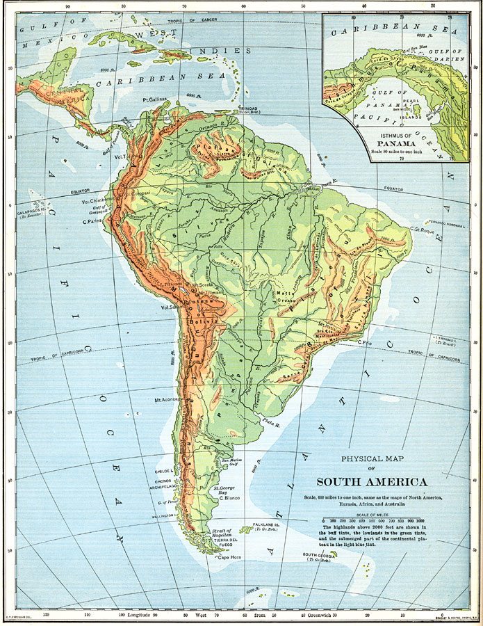
Description: A map from 1898 of South America showing the general physical features including mountain systems, prominent peaks and volcanoes, river and lake systems, plateaus, and coastal features. The map includes an insert of the Isthmus of Panama. "The Andes Mountains are much loftier than the ranges of the North American highland, and are much less broken. They follow the north and west coasts as a continuous wall, from the vicinity of the island of Trinidad nearly to the Strait of Magellan. Except near the extremities there are few passes across the chain less than two miles high, while many of the peaks are four miles in height, and are the highest in America. Even in the torrid zone these lofty peaks always bear snow and glaciers near their summits, and in the south glaciers descend to the sea. Thirty or forty active volcanoes occur along the Andes and many of the high peaks are huge volcanic cones. Severe earthquakes are common throughout the chain, and sometimes cause great loss of life. On the west slopes of the Andes are many terraces and shell deposits high above the present sea level, marking old positions of the sea beach...The Brazilian plateau is much lower than the Andean highland. Its general height is less than half a mile. Much of its surface is quite level, but there are numerous rugged divides and several mountain ranges, with at least one peak two miles high. The plateau slopes abruptly in the east to a narrow coast plain, but inland it merges gradually in to he great central lowland...The eastern highlands of South America, like those of North America, are much older than the western highlands." — Redway, 1898.
Place Names: A Complete Map of South America, Andes Mountains, �Amazon River, �Cape Horn, �Atlantic Ocean, �Pacific Ocean, �Caribbean Sea, �West Indies, �Gulf of Mexico, �Central America, �Plateau of Guiana, �Plateau of Brazil, �Lake Titicac
ISO Topic Categories: elevation,
inlandWaters,
oceans
Keywords: Physical Map of South America, physical, �transportation, �historical, physical features,
topographical, water routes, elevation,
inlandWaters,
oceans, Unknown,1898
Source: Jacques W. Redway and Russell Hinman, Natural Advanced Geography (New York, NY: American Book Company , 1898) 102
Map Credit: Courtesy the private collection of Roy Winkelman |
|