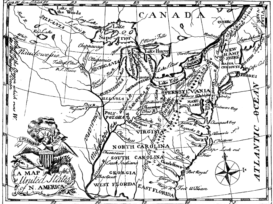
Description: A facsimile of a map from Francis Bailey's Pocket Almanac (1785) showing the Northwest Territory of the United States and the land divisions proposed by the Ordinance of 1784. The Ordinance of 1784 called for all land between the Mississippi River and the Appalachian Mountains and north of the Ohio River to be separated into ten states. The map shows the ten states proposed by Jefferson: Assenisippia, Cherronesus, Illinoia, Metropotamia, Michigania, Pelisipia, Polypotamia, Saratoga, Sylvania, and Washington. The next year, the Land Ordinance of 1785 was passed in order to clearly define how the land was to be divided.
Place Names: Early America 1400-1800, Pennsylvania, �New Hampshire, �North Carolina, �South Carolina, �Rhode Island, �Connecticut, �New Jersey, �Delaware, �Maryland, �Virginia, �Georgia, �West Florida, �East Florida, �Florida, �Canada, �Ordinance of 1784,
ISO Topic Categories: boundaries,
inlandWaters,
society
Keywords: Division of States according to the Ordinance of 1784, physical, �political, �historical, �Land Ordinance of 1785, �physical features, country borders,
major political subdivisions, historical event, boundaries,
inlandWaters,
society, Unknown,1784
Source: Justin Winsor, Narrative and Critical History of North America Vol. VII (Boston, MA: Houghton, Mifflin and Company, 1888) 529
Map Credit: Courtesy the private collection of Roy Winkelman |
|