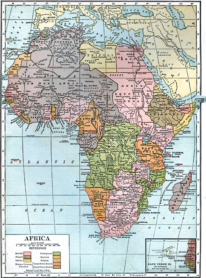
Description: A map of Africa in 1920 showing colonial possessions of the British, French, Italian, Portuguese, Spanish, and Belgians, including the former German colonies, lost after WWI, to French and British control per the Treaty of Versailles. This map shows major cities and trade centers, major rivers, deserts, and landforms, and re–established native land boundaries such as Swaziland and Basotoland. An inset map shows the Portuguese controlled Cape Verde Islands.
Place Names: A Complete Map of Africa, Morocco, �Algeria, �Tripoli, �Egypt, �Anglo-Egyptian Sudan, �Abyssinia, �Asmara, �Somaliland, �Italian Somaliland, �Nairobi, �French West Africa, �Liberia, �Nigeria, �Kamerun, �Angola, �Belgian Kongo, �South West Africa, �Union of South Africa, �Madagascar, Cape Verde Islands, Orange Free State, Northern Rhodesia, Southern Rhodesia, Mozambique, East Africa, East African Protectorate, Uganda Protectorate, French Equatorial Africa, Togo, Gold Coast, Rio de Oro, Italian Somaliland, Eritrea, Morocco
ISO Topic Categories: boundaries,
inlandWaters,
location,
oceans,
society
Keywords: Africa, physical, �political, kBerlinConference, kVersailles, physical features, country borders,
major political subdivisions, boundaries,
inlandWaters,
location,
oceans,
society, Unknown, 1920
Source: , Leslie's New World Atlas (New York City, New York: Leslie-Judge Company, 1920) 30
Map Credit: Courtesy the private collection of Roy Winkelman |
|