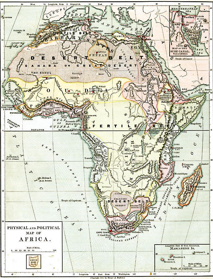
Description: Map of pre-colonial Africa, showing the predominately native countries and territories of the African continent in 1879. The counties include the Barbary States of Morocco, Algeria, Tunis, Tripoli and Fezzan, the Egyptian territories of Egypt Proper, Nubia, and Egyptian Sudan, the Somali, Abyssinia, Zanguebar, Mozambique, Sofala, and Madagascar, the Upper Guinea countries of Senegambia, Sierra Leon, Liberia, and Ashantee-Dahomey, and the Lower Guinea countries of the Loango, Congo, Angola, and Benguela. The map also shows the European possessions of the Cape Colony, Transvaal Republic, Orange River Republic, and Natal. The map shows various regions of the continent as fertile belts and desert belts, and indicates major trade goods produced in the regions such as palm oil, ivory, skins, and cattle. Major cities are shown, with important trade centers highlighted with a red cross mark. Major Ocean currents are shown, including the Equatorial Current, South Atlantic Current, Agulhas Current, and the Mozambique Current. Two inset maps detail the Nile Delta and Suez Canal, and the Mascarene Islands. This map is apparently intended for US students in that longitude is shown from the Greenwich prime meridian at the top of the map, and from the Washington prime meridian at the bottom of the map. Also, an outline map of Ohio is included at the same map scale to show the comparative area size relationship.
Place Names: A Complete Map of Africa, Barbary States, �Algeria, �Soudan, �Upper Ginea, �Kongo State, �Lower Guinea, �Cape Colony, �Somali, �Nubia, �Egypt, �Alexandria, �Madagascar, �Mozambiqu
ISO Topic Categories: boundaries,
inlandWaters,
location,
oceans
Keywords: Physical and Political Map of Africa, physical, �political, kAfricanNativeStates, kComparativeArea, kSuezCanal, physical features, country borders,
major political subdivisions, boundaries,
inlandWaters,
location,
oceans, Unknown, 1879
Source: , Harper's School Geography (New York City, New York: American Book Company, 1894) 114
Map Credit: Courtesy the private collection of Roy Winkelman |
|