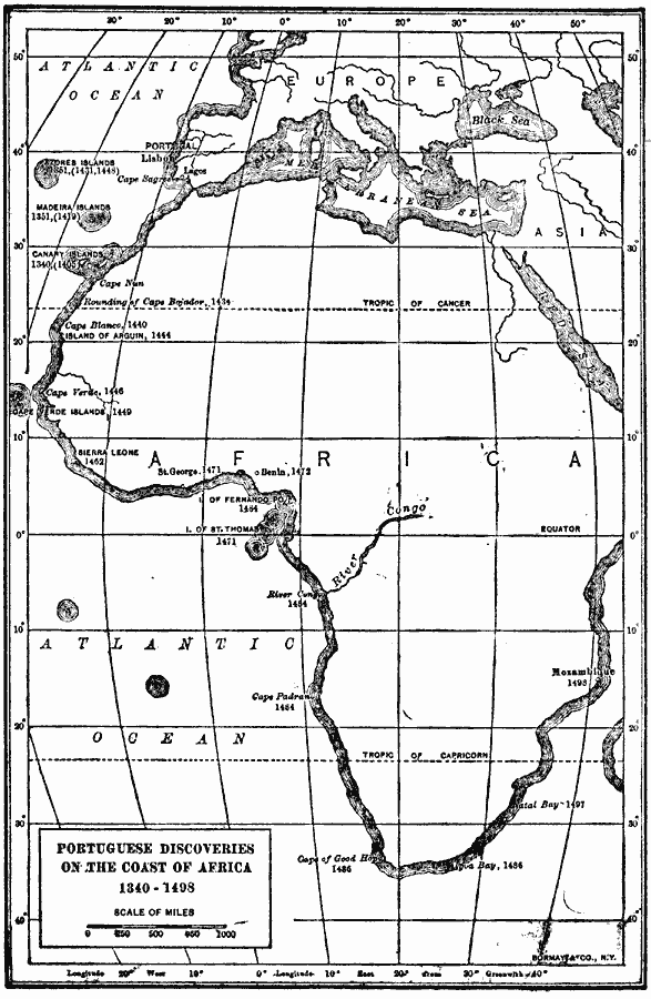
Description: A map of Africa from 1906 showing Portuguese discoveries along the coast from 1340 to 1498. The map shows Cape Sagres and Lagos, Portugal, point of embarkation for voyages of exploration under Prince Henry "the Navigator" (1394-1460). This map shows the Portuguese discovery dates for the Canary Islands (1340, with the beginning of Spanish control in 1405), Madeira Islands (1351, rediscovered and colonized in 1419), Azores Islands (1351, rediscovered and colonized in 1431 and 1448), the rounding of Cape Bojador by Gil Eannes (1434), Cape Blanco (1441) and the island of Arguin (1444) by Nuno Tristam (Tristão), Cape Verde (1446) and Cape Verde Islands (1449) by Dinis Diaz (Diogo Dias or Diego Gomez), Sierra Leon, or Serra de Leão by Pedro de Cintra (1462), St. George or São Jorge da Mina on the Gold Coast (1471), Island of St. Thomas, or São Tomé (1471), Benin, Nigeria (1472), Island of Fernando Po (Bioko) (1484), the mouth of the River Congo (1484), Cape Padrano (1484), Cape of Good Hope by Bartholomew Diaz (1486), Cape Agulhas (1486), Natal Bay (1497) and Mozambique (1498) by Vasco de Gama.
Place Names: A Complete Map of Africa, Africa, �Asia, �Europ
ISO Topic Categories: inlandWaters,
location,
oceans
Keywords: Portuguese Discoveries in Africa, physical, physical features, inlandWaters,
location,
oceans, Unknown, 1340–1498
Source: Albert Bushnell Hart, LL.D., The American Nation Vol 1 (New York, NY: Harper and Brothers, 1906) 71
Map Credit: Courtesy the private collection of Roy Winkelman |
|
