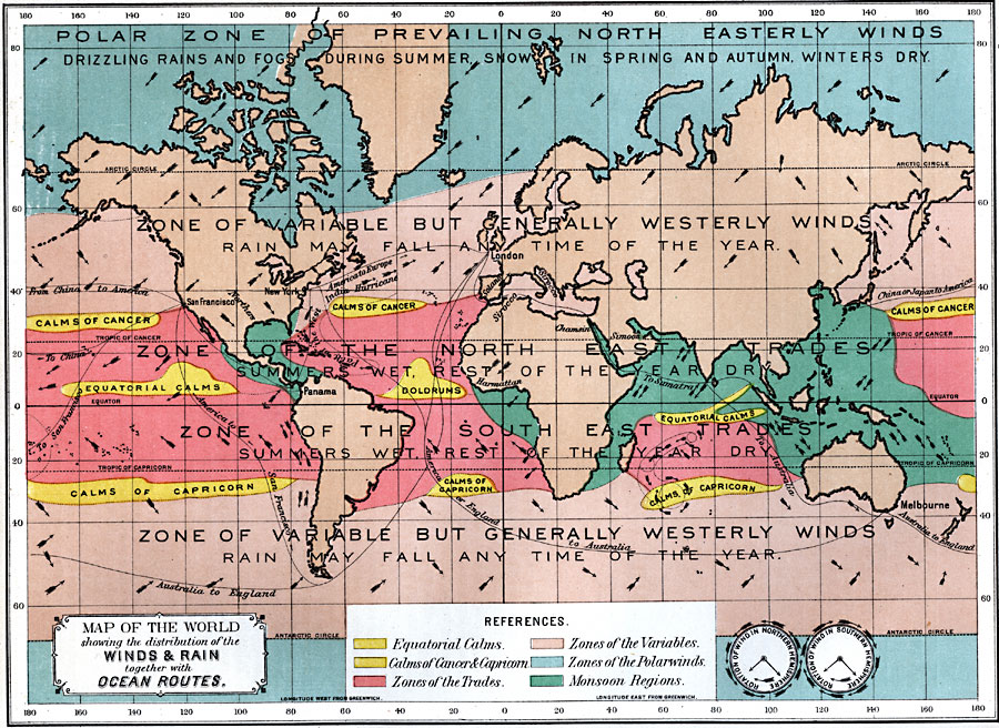
Description: A world map from 1891 showing the distribution of the winds and rain, together with ocean routes. This map is color-coded to show Equatorial Calms and Doldrums, Calms of Cancer and Capricorn, Zones of the Trades, Zones of the Variables, Zones of the Polar Winds, and Monsoon Regions. The map notes the areas of drizzling rains and fogs during summer, with snow in spring and autumn, and winters dry, areas where rain may fall at any time of the year, and areas where the summers are wet, rest of the year dry. Zones of prevailing winds are shown, including the polar zone of north-easterly winds, the north and south zones of variable but generally westerly winds, zone of the north east trades, and the zone of the south east trades. Prevailing wind directions are shown, with seasonal wind directions shown in the monsoon regions and along the west coast of South America. Specific winds are shown, including the Sirocco (Mediterranean), Solano (Spain), Simoon (Arabian Peninsula), Chamsin (Egypt), Harmattan (West Africa), Northers (central North America), Clock faces illustrate the rotation of winds in the northern and southern hemispheres. Principal ocean routes between continents are shown.
Place Names: A Complete Map of Globes and Multi-continent, Africa, �Antarctica, �Asia, �Australia, �Europe, �North America, �South Americ
ISO Topic Categories: oceans,
location,
inlandWaters,
climatologyMeteorologyAtmosphere
Keywords: Map of the World showing the distribution of the Wind & Rain together with Ocean Routes, climate, �land, �meteorological, �rainfall, �wind, kClimate, temperature,
climate,
rainfall,
winds, oceans,
location,
inlandWaters,
climatologyMeteorologyAtmosphere, Unknown, 1891
Source: Edwin J. Houston, A. M. , The Elements of Physical Geography (Philadelphia, PA: Eldredge & Brother, 1891) 94
Map Credit: Courtesy the private collection of Roy Winkelman |
|
