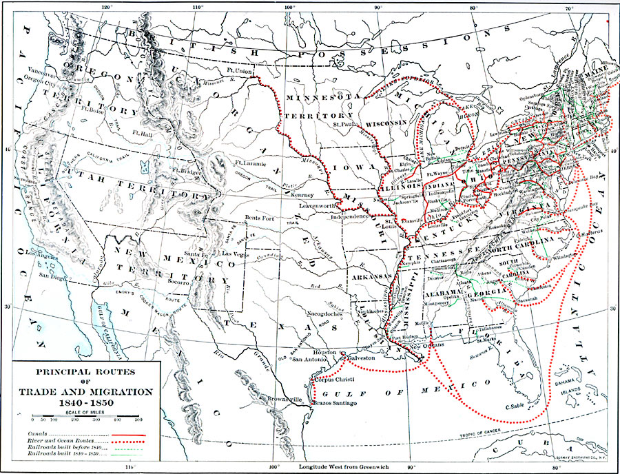
Description: A map of the United States between 1840 and 1850 showing the states and territories, and the principal routes of transportation and westward migration during the period. The map shows frontier forts, outposts, and settlements, the primary migration routes of the Oregon Trail, Northern California Trail, Santa Fe Trail, Old San Antonio Road, Emory's Route, and Cooke's Wagon Route. The map also shows canal routes, river and ocean routes, railroads built before 1840, and railroads built between 1840 and 1850.
Place Names: Transportation, Alabama, �Arkansas, �California, �Connecticut, �Florida, �Illinois, �Indiana, �Iowa, �Louisiana, �Michigan, �Minnesota Territory, �Mississippi, �Missouri, �New Mexico Territory, �New York, �North Carolina, �Ohio, �Oregon Territory, �Pennsylvania, �So
ISO Topic Categories: oceans,
location,
inlandWaters,
transportation
Keywords: Principal Routes of Trade and Migration, economic, �railroads, �statistical, �transportation, �water routes, kTransportation, economic, water routes,
railroads, oceans,
location,
inlandWaters,
transportation, Unknown, 1840–1850
Source: Dixon Ryan Fox, Harper's Atlas of American History (New York, NY: Harper & Brothers Publishers , 1920) 47
Map Credit: Courtesy the private collection of Roy Winkelman |
|