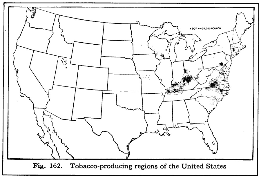
Description: A map from 1916 of the United States showing the tobacco–producing areas at the time. "Almost all of the tobacco in this country is raised east of the Mississippi River. Kentucky grows the most, — about three times as much as either Virginia or North Carolina, which rank next in the amount of tobacco produced. The fine quality of much of the North Carolina tobacco gives it special value, so that this state stands second to Kentucky in the value of its crop. Richmond is a very large tobacco market and manufacturing center, and much tobacco is manufactured also in Durham and Winston–Salem in North Carolina, and at Key West and Tampa in Florida. A part of the tobacco used in Key West and Tampa is raised in Cuba." — Brigham and McFarlane, 1916, p. 104.
Place Names: Agriculture, tobacc
ISO Topic Categories: farming,
boundaries,
inlandWaters,
oceans,
location,
transportation
Keywords: Tobacco Producing Regions, political, �statistical, kAgriculture, country borders,
major political subdivisions, agriculture, farming,
boundaries,
inlandWaters,
oceans,
location,
transportation, Unknown, 1916
Source: Albert Perry Brigham & Charles T. McFarlane, Essentials of Geography (New York, NY: American Book Company, 1916) 104
Map Credit: Courtesy the private collection of Roy Winkelman |
|