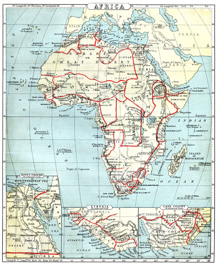
Description: This is an interesting map of Africa showing the continent before the Berlin Conference of 1885, when the most powerful countries in Europe at the time convened to make their territorial claims on Africa and establish their colonial borders at the start of the New Imperialism period. The map shows several of the initial European footholds in Africa, such as the Cape Colony, the Colony of Natal, and Orange River Republic in the south, but of perhaps greater significance, this map shows the territorial lands of native groups at the time. These include the lands of the Bechuanas, Zoolus, and Hottentots in the south, the Guinea, Loango, Cimbebas and Damaras along the west coast, the Mozambique, Zanguebar and Somaulies of the east coast, the Egyptian, Barca, Fezzan, and others along the Mediterranean Barbary, and the Senegambia, Bambarra, Houssa, and Bornou of western Africa. This unique map also illustrates the contrast between the practice of native peoples establishing natural territorial borders along rivers, mountain ranges, trade routes, or spheres of influence, and the typically European establishment of abstract cadastral or surveyed boundaries. The map also shows the locations and dates of important findings by European explorers such as Livingston, Speke, Burton, and Baker. Inset maps include a map of Egypt Proper, which shows the Nile delta, railroads, and the Suez Canal, a map of Liberia, which shows the capital Monrovia and the neighboring countries Sierra Leon and Maryland, and an enlarged scale map of the Cape Colony.
Place Names: A Complete Map of Africa, Morocco, �Algeria, �Tunis, �Tripoli, �Egypt, �Soudan, �Senegambia, �Guinea, �Congo State, �Nubia, �Abyssinia, �Zanguebar, �Mozambique, �Cape Colony, �Angola, �Madagascar, �Liberia, Caffraria, Natal, Sierra Leon, Maryland, Country of the Somaulies, Fezzan, Beled el Jerid, Country of Dates
ISO Topic Categories: boundaries,
inlandWaters,
location,
oceans
Keywords: Africa before the Berlin Conference, physical, �political, kAfricanNativeStates, kBerlinConference, kNaturalCadastralBoundaries, kSuezCanal, physical features, country borders, boundaries,
inlandWaters,
location,
oceans, Unknown, 1884
Source: , Cornell's Intermediate Geography (New York, New York: American Book Company, 1888) 81
Map Credit: Courtesy the private collection of Roy Winkelman |
|