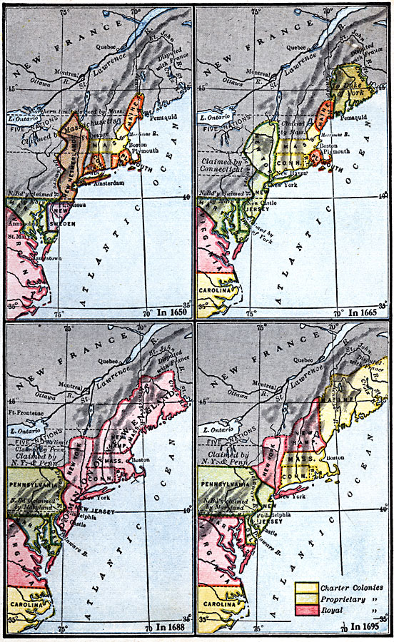
Description: A series of maps showing the development and colonial claims of the northern Atlantic Coast between 1650 and 1695. The maps are color–coded to show charter colonies, proprietary colonies, and the royal colonies. The map from 1650 shows the colonies of New Netherlands and New Sweden, the area of the Five Nations, the northern boundary claimed by Massachusetts, and the area to the north disputed with France. The map from 1665 shows New Sweden (Delaware) and the territory north of Maine claimed by the Duke of York, New Netherlands claimed as New York, the territories claimed by Connecticut and Massachusetts, and the area to the north disputed with France. The map from 1688 shows the Dominion of New England and the territories claimed jointly by Pennsylvania and New York. The map from 1695 shows the territories claimed jointly by Pennsylvania and New York, and the extent of New Hampshire and Maine at the time.
Place Names: Early America 1400-1800, Connecticut, �New Sweden, �Maryland, �Maine, �Massachusetts, �New Netherlands, �Plymouth, �Pennsylvania, �Virginia, �Carolina, �Maryland, �Colonial America, �New England, �Mid-Atlantic States, �Middle Atlantic State
ISO Topic Categories: boundaries,
location,
inlandWaters,
oceans
Keywords: Atlantic Coast Development, physical, �political, physical features, major political subdivisions, boundaries,
location,
inlandWaters,
oceans, Unknown, 1650–1695
Source: Robert Hall, Harriet Smither, and Clarence Ousley, A History of the United States (Dallas, TX: The Southern Publishing Company, 1920) 85
Map Credit: Courtesy the private collection of Roy Winkelman |
|
