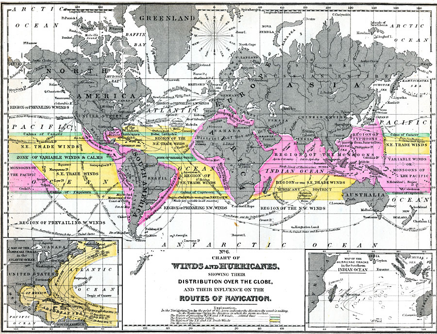
Description: A world chart from 1890 of winds and hurricanes showing their distribution on the globe, and their influence on the routes of navigation. This map shows major sailing routes between San Francisco, New York, New Orleans, Callao, Europe, Calcutta, Canton, Shanghai, Melbourne, and Yezo Hakodate (Japan), with seasonal wind conditions of various regions. In the navigation tracks, the point of the arrow indicates the direction the vessel is sailing, and in the hurricane circles, the point of the arrows indicates the direction in which the storms revolve. The map is color-coded to show the regions of prevailing W.N.W and S.W. winds, regions of prevailing calms, regions of N.E and S.E. Trade Winds, and the Monsoon regions. There is an inset showing major hurricane tracks with dates in the Atlantic Ocean from 3 October, 1780, to 10 August, 1831, and an inset of hurricane tracks in the Southern Indian Ocean.
Place Names: A Complete Map of Globes and Multi-continent, Africa, �Asia, �Antarctica, �Australia, �Europe, �North America, �South Americ
ISO Topic Categories: inlandWaters,
location,
oceans,
climatologyMeteorologyAtmosphere
Keywords: Chart of Winds and Hurricanes, physical, �meteorological, kClimate, physical features, winds, inlandWaters,
location,
oceans,
climatologyMeteorologyAtmosphere, Unknown, 1890
Source: John Brocklesby, Elements of Physical Geography (Philadelphia, Pennsylvania: E. H. Butler and Co., 1890) 92
Map Credit: Courtesy the private collection of Roy Winkelman |
|