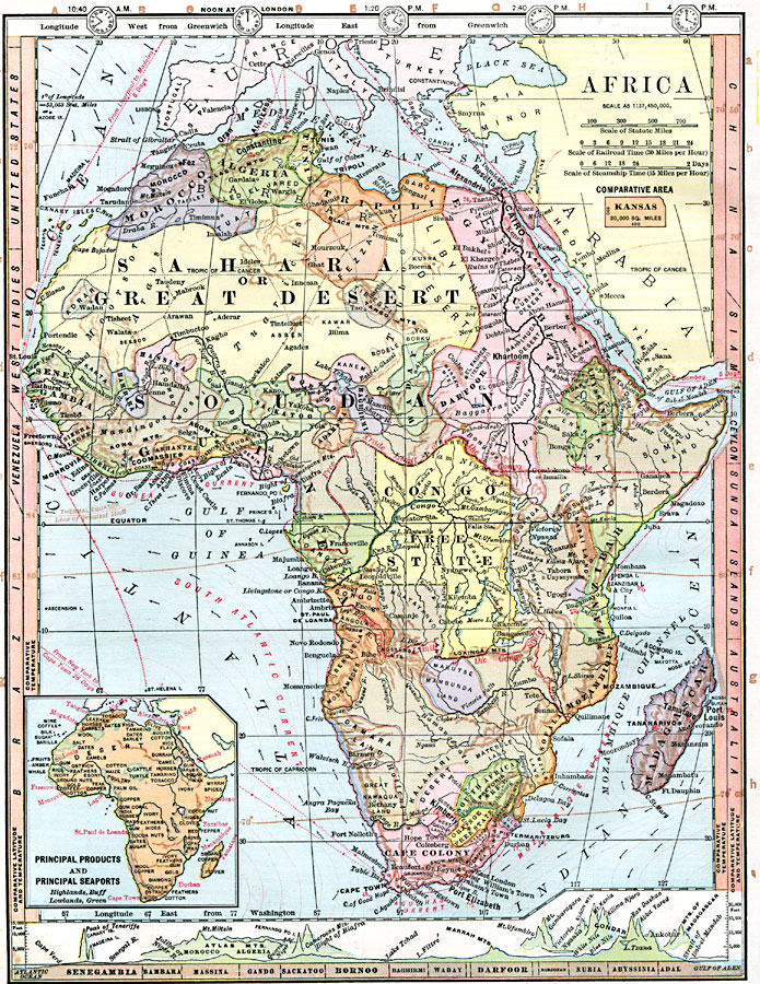
Description: A map of Africa showing the continent prior to the Berlin Conference of 1885, when the most powerful countries in Europe at the time convened to make their territorial claims on Africa and establish their colonial borders at the start of the New Imperialism period. The map shows the European possessions of Cape Colony, Orange Free State, South Africa, and the Congo Free State controlled by Leopold II of Belgium. The Congo Free State was established as a corporate state, similar to the British East India Company, for the purpose of developing a trade monopoly in Africa. This map shows the borders of Congo Free State and the boundary limit of free trade to the north and south by dashed red lines. This free trade zone essentially cut a swath for Belgium across central Africa from the Atlantic to the Indian Ocean. Of significant interest, this map shows the native African States and indicates the major tribes of the continent. The African States include Marutse-Manbunda Land, Damara Land, Great Namaqua, and Zulu Land in the south, Masai Land, Zanzibar, and Somauli Land in the east, Darfoor, Kordofan, Abyssinia, Nubia, and Egypt in the northeast, Tripoli, Fezzan, Tibesti, Tunis, Algeria, and Morocco along the Mediterranean and Barbary, and Adrar, Sene-Gambia, Karta, Bambara, Massina, Tombo, Mossi, Ashantee, Dahomey, Gando, Yoruba, Benin, Saukatoo, Bornoo, Adamawa, Baghirmi, and Waday in the west. This map also shows the transportation significance of the continent with railroad times scaled at 30 miles per hour and steamship times between major world ports scaled at 15 miles per hour. Caravan trade routes are also shown. Current flow directions are indicated, and major currents are named, including the Mozambique, Agulhas, South Atlantic, and Guinea currents. Time zones are indicated at the top of the map at 20 degree intervals from 12 noon, London. A cross-section of the continent is shown at the bottom of the map, running approximately along the 15th parallel from Cape Verde on the Atlantic to the Strait of Bab-el-Mandeb on the Gulf of Aden, and includes comparative vertical profiles of Africa's major mountains. Comparative latitudes and temperatures for western hemisphere continents are shown on the left-hand edge of the map, with the eastern hemisphere on the right-hand edge. Longitude from Greenwich is shown at the top of the map, with longitude from Washington at the bottom. The inset map of principle products and principle seaports of the continent also indicate general elevations with highlands in buff color, and lowlands in green. An outline map of Kansas is included at the same map scale to show the comparative area size relationship.
Place Names: A Complete Map of Africa, Egypt, �Congo, �Algeria, �Madagascar, �Morocco, �Tunis, �Tripoli, �Cape Colony, �South Africa, �Mozambique, �Zanzibar, �Somauliland,�Abyssinia,
ISO Topic Categories: boundaries,
oceans,
location,
inlandWaters,
elevation,
climatologyMeteorologyAtmosphere,
transportation,
economy,
farming
Keywords: Pre-Colonial Africa, physical, �political, �transportation, �hydrological, �meteorological, kAfricanNativeStates, kBerlinConference, kComparativeArea, physical features, country borders, water routes, temperature, currents, boundaries,
oceans,
location,
inlandWaters,
elevation,
climatologyMeteorologyAtmosphere,
transportation,
economy,
farming, Unknown, 1872
Source: James Monteith, Comprehensive Geography (New York, New York: A. S. Barnes and Company, 1872) 84
Map Credit: Courtesy the private collection of Roy Winkelman |
|