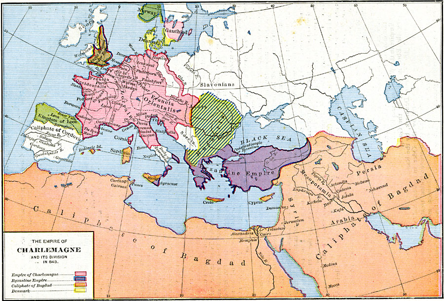
Description: A map of Europe at the time of Charlemagne showing the extent of his empire in AD 843, including Francia Occidentalis, Lorraine, and Francia Orientalis. The map is color coded to show the territories of Norway, Gauthiod (Sweden), Denmark, Welshland, the Scots, the Anglo Saxons under Egbert, the Slavonians, Kingdom of Leon, Bulgaria, Servia, Duchy of Beneventum, and the Byzantine Empire. This map also shows the territories of the Caliphate of Bagdad in North Africa and Asia Minor, and the Caliphate of Cordova on the Iberian Peninsula. The map shows important cities of the time, and major rivers.
Place Names: Regional Miscellaneous, Africa, �Andalos, �Bulgaria, �Byzantium, �Crete, �Cyprus, �Denmark, �Iran, �Italy, �Mesopotamia, �Persia, �Serbia, �Sicil
ISO Topic Categories: borders, kWorldMedSea, kWorldAfroAsia, kWorldEurasia, kWorldEuroAfrica
Keywords: The Empire of Charlemagne and its Division, borders, borders, kWorldMedSea, kWorldAfroAsia, kWorldEurasia, kWorldEuroAfrica, Unknown, A.D. 843
Source: Robert H. Labberton, New Historical Atlas and General History (New York, NY: Townsend MacCoun, 1886) Plate XXVIII
Map Credit: Courtesy the private collection of Roy Winkelman |
|