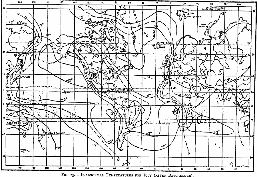
Description: A world map from 1896 showing the global isabnormal temperatures for July. "The irregular distribution of temperatures over the earth is best shown by considering the difference between the average temperature of each parallel and the actual temperature at places along the same parallel. These differences are called the abnormal temperatures of those places. The abnormal temperatures are charted, and the lines of equal magnitudes drawn on the charts are called is-abnormals...In the chart (Fig. 13), the minimum negative abnormal temperatures are -10° F. on the northeastern part of the Pacific Ocean, on the North Atlantic between southern Greenland and the North American Continent, and to the west of South America and Africa a few degrees south of the Equator. The maximum positive abnormal temperatures are +20° F. in the north-western United States (inland), +10° F. in central Asia, and +10° F. over the desert of northern Africa. In the southern hemisphere there is a slight negative abnormal temperature in central Australia. Over the greater parts of South America and Africa there is a slight positive abnormal temperature both in winter and summer, while over the ocean to the west of these the air is abnormally cool." — Waldo, 1896, pp.58-60.
Place Names: A Complete Map of Globes and Multi-continent, Africa, �Antarctica, �Asia, �Australia, �Europe, �North America, �South Americ
ISO Topic Categories: inlandWaters,
location,
oceans,
climatologyMeteorologyAtmosphere
Keywords: Isabnormal July Temperatures, physical, �meteorological, kClimate, physical features, temperature, inlandWaters,
location,
oceans,
climatologyMeteorologyAtmosphere, Unknown, 1896
Source: Frank Waldo, Elementary Meteorology (New York, New York: American Book Company, 1896) 61
Map Credit: Courtesy the private collection of Roy Winkelman |
|