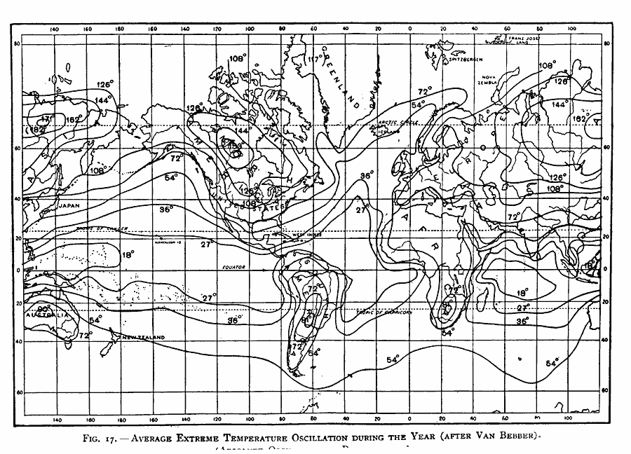
Description: A world map from 1896 showing global average annual extreme temperature oscillation, with absolute oscillation in parentheses. "The average extreme oscillation or amplitude of the temperature during the year, increases with the latitude and towards the interior of continents, but decreases with the altitude. The lines of equal amounts of the extreme temperature oscillation during the year are drawn on the chart at intervals of 9° F. These curves bring out most clearly the difference between the continental and marine climates. On the ocean near the equator the absolute temperature amplitude becomes less than 18° F. It increases, however, towards the poles and towards the continents, and especially towards the interior of the continents. In eastern Asia an average amplitude of 171° F. (in a single case over 180° F.), and in North America 153° F., is reached; but at the interior of Australia the amplitude is only 90° F., and in South America only 81° F." — Waldo, 1896, p. 67.
Place Names: A Complete Map of Globes and Multi-continent, Africa, �Antarctica, �Asia, �Australia, �Europe, �North America, �South Americ
ISO Topic Categories: climatologyMeteorologyAtmosphere,
inlandWaters,
location,
oceans
Keywords: Temperature Oscillation, physical, �meteorological, kClimate, physical features, temperature, climatologyMeteorologyAtmosphere,
inlandWaters,
location,
oceans, Unknown, 1896
Source: Frank Waldo, Elementary Meteorology (New York, New York: American Book Company, 1896) 68
Map Credit: Courtesy the private collection of Roy Winkelman |
|