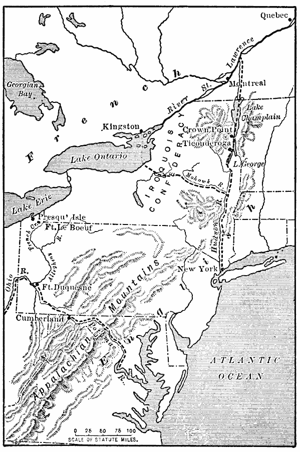
Description: A map of the Appalachian Mountain region showing the three primary routes of the early 1700's through the natural barrier from the English colonies to the Mississippi Valley. "The Appalachian ranges separated the French and the English, and inasmuch as these mountains produced nothing that either side cared for, they formed an excellent ‘buffer’ territory between the two. In these ranges, however, were three important gateways between the English and the Mississippi Valley. The chief of these was the Mohawk River gap. As this was held by the Iroquoians, the French had not attempted to interfere there; however, they built a fort at Kingston, opposite the present site of Oswego, New York. The next in importance as a gateway was the valley of Lake Champlain. There was clear sailing over the lake from head to foot, and the trails along the lake from the Hudson to the St. Lawrence were level enough for a wagon road. At Crown Point, a peninsula that cuts the lake almost in two, the French built a fort. On Ticonderoga, a tableland that commands a narrow view of the lake, they built another. There was still another pass across the mountains, namely, the gap along the Potomac and Cumberland and across the divide to the Ohio. It had become an important route from Virginia to the Ohio River, and the French were not slow to see the value of it. They also established Fort le Boeuf in the valley of French Creek, a few miles south of Lake Erie." — Redway, 1911, p. 113.
Place Names: Early America 1400-1800, Canada, �Montreal, �New York, �Quebec, �United State
ISO Topic Categories: oceans,
location,
inlandWaters
Keywords: Gateway Through the Appalachians, political, �transportation, local jurisdictions, water routes, oceans,
location,
inlandWaters, Unknown, Late 1600s–early 1700s
Source: Jacques W. Redway, F.R.G.S., The Redway School History (New York, NY: Silver, Burdett and Company, 1911) 114
Map Credit: Courtesy the private collection of Roy Winkelman |
|