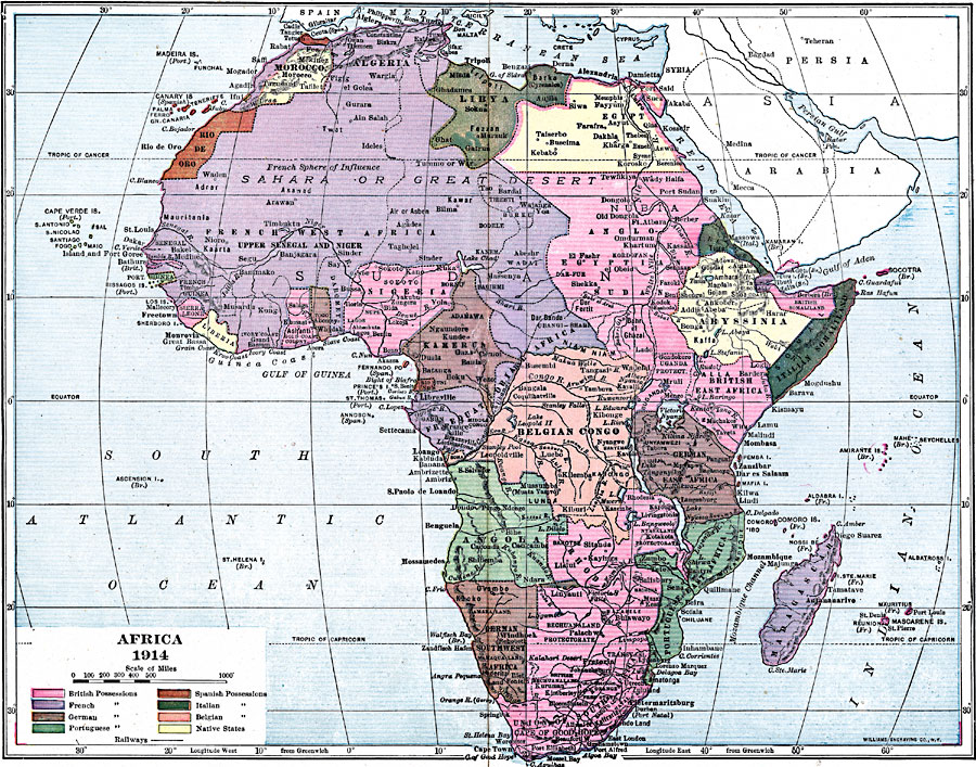
Description: A map of Africa in 1914, showing the presence of European powers, including British, French, German, Portuguese, Spanish, Italian, and Belgian possessions. Native states, major cities and major railways are also shown. This map reflects European imperialism on the African continent after the Berlin Conference of 1885. Country names such as French West Africa, Anglo Egyptian Sudan, British Somaliland, Italian Somaliland, British East Africa, Belgian Congo, German East Africa, Portuguese East Africa, and German Southwest Africa clearly illustrate the European land claims.
Place Names: A Complete Map of Africa, Congo, �Madagascar, �South Africa, �Sudan, �Somalia, �Nigeria, �Egypt, �Algeria, French West Africa, Anglo Egyptian Sudan, Italian Somaliland, British East Africa, Belgian Congo, German East Africa, Portuguese East Africa, German Southwest Africa, Union of South Africa, Rhodesia, Abyssinia, Eritrea, Rio de Oro
ISO Topic Categories: boundaries,
location,
oceans,
inlandWaters
Keywords: Colonial Africa, physical, �political, kBerlinConference, physical features, country borders, boundaries,
location,
oceans,
inlandWaters, Unknown, 1914
Source: Lucius Hudson Holt, Ph.D., The History of Europe from 1862 to 1914 (New York, NY: The Macmillan Company, 1918) 334
Map Credit: Courtesy the private collection of Roy Winkelman |
|