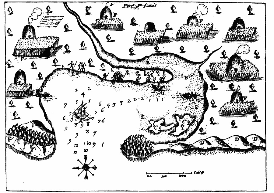
Description: A facsimile from a map by Samuel Champlain (1613) of the Plymouth Bay, here called Port St. Louis by Champlain, as explored by the French prior to the landing of the Pilgrims in 1620. The map is keyed to show (A) anchoring–place, (B) channel, (C) two islands (the left–hand one seems to be what is now known as Saquish, a peninsula connected at present with the Gurnet Head, here marked H; the right– one is the present Clark's Island), (D) sand–hills (apparently the low sand–hills of Duxbury Beach), (E) shoals, (F) cabins and tillage ground of the natives, (G) beaching–place of our barque (apparently the present Powder Point), (H) land like an island, covered with wood (the present Gurnet Head), and (I) high promontory, seen four or five leagues at sea. "This promontory has usually been called Manomet, and if the right–hand of the map is north, it has the correct bearing from the Gurnet; but it is in that case very strange that so marked a feature as the sand–spit known as Plymouth Beach is not indicated, and no sign is given of the conspicuous eminence known as Capitan's Hill. If, however we consider the top of the map north (and the engraver may be accountable for the erroneous fashioning of the points of the compass), it becomes at once perfectly comprehensible as a sketch of that part of the bay known as Duxbury Harbor, and would not, accordingly, show that part of the shore on which the Pilgrims landed. In this view the hill (I) becomes Capitan's Hill, and the rest of the plan, though but rudely conforming to the lines of Duxbury Harbor, is much more satisfactory in its topographical correspondences than the other theory would allow." — Winsor, 1884, pp. 109–110.
Place Names: Massachusetts, Port St. Loui
ISO Topic Categories: oceans,
location,
inlandWaters
Keywords: Port St. Louis or Plymouth Bay, borders, �physical, kEarlyMapsFacsimile, oceans,
location,
inlandWaters, Unknown, 1613
Source: Justin Winsor, Narrative and Critical History of America (vol. 4) (Boston, MA: Houghton, Mifflin, and Company, 1884) 109
Map Credit: Courtesy the private collection of Roy Winkelman |
|