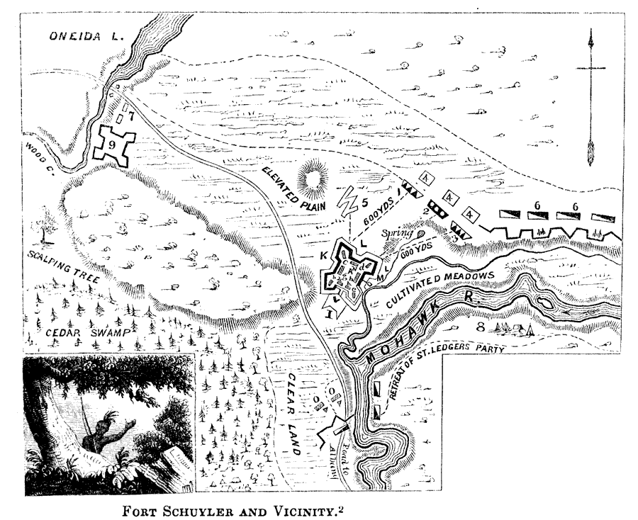
Description: A map of Fort Schuyler (Fort Stanwix) and vicinity at the southern end of Lake Oneida and Mohawk River, site of the Battle of Oriskany (August 6, 1777). The map shows the events of this battle, and is keyed to show: (A) Fort Schuyler; (b) southwest bastion, three guns; (c) northwest bastion, four guns; (d) northeast bastion, three guns; (e) southeast bastion, four guns; (g) laboratory; (h) barracks; (I) horn–works begun; (K) covered way; (L) glacis; (M) sally–port; (N) officers' quarters; (O) Willett's attack. (1) a battery of three guns; (2) bomb battery, four mortars; (3) bomb battery of three guns; (4) redoubts to cover the batteries; (5) line of approaches; (6) British encampment; (7) Loyalists; (8) Indians; (9) ruins of Fort Newport. — Lossing, 1851, p.249.
Place Names: Early America 1400-1800, Oneida Lake, �Mohawk River, �Fort Schuyler, ��American Revolutio
ISO Topic Categories: structure,
inlandWaters,
location,
intelligenceMilitary
Keywords: Fort Schuyler and Vicinity, physical, �historical, kAmericanRevolution, physical features, American Revolution, structure,
inlandWaters,
location,
intelligenceMilitary, Unknown, 1777
Source: Benson J. Lossing, Pictorial Field-Book of the Revolution Vol. I (New York, NY: Harper and Brothers, 1851) 249
Map Credit: Courtesy the private collection of Roy Winkelman |
|