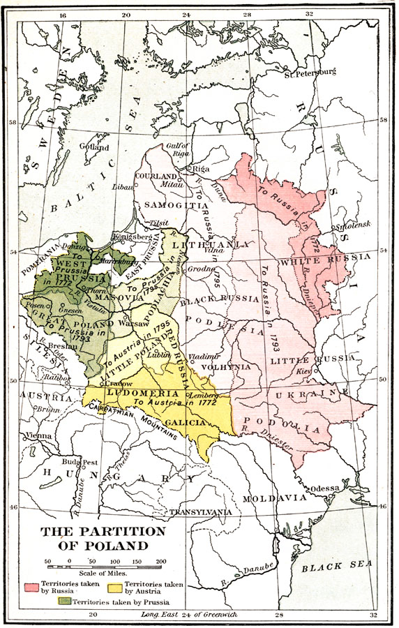
Description: Map of Poland highlighting territories taken by Russia, Austria, and Prussia. "The other case, the Partition of Poland, was the most iniquitous act of the century. Poland was in geographical extent the largest state in Europe, next to Russia. Its history ran far back. But its government was utterly weak. Therefore in 1772 Prussia, Austria, and Russia attacked it for no cause save their own cupidity, and tore great fragments away, annexing them to their own territories. Twenty years later they completed the process in two additional partitions, in 1793 and 1795, thus entirely annihilating an ancient state. This shows how much regard the monarchs of Europe had for established institutions, for established authorities." — Hazen, 1917
Place Names: Poland, Krakow, �Lublin, �Warsaw, �Tilsit River, �River Vistula, �River Dniester, �Carpathian Mountains, �Samogitia, �Podlachia, �Podlesia, �Podolia, �Ludomeria, �Baltic Sea, �Black Sea,
ISO Topic Categories: boundaries,
inlandWaters
Keywords: The Partition of Poland, physical, �political, �historical, physical features, country borders,
major political subdivisions,
local jurisdictions, boundaries,
inlandWaters, Unknown, 1772–1795
Source: Charles Downer Hazen, The French Revolution and Napoleon (New York, NY: Henry Holt and Company, 1917) 54
Map Credit: Courtesy the private collection of Roy Winkelman |
|