The Structural Geology ClipArt gallery provides 172 illustrations of the study of the stresses and deformations of rock layers. The study of the various folds and deformations of rock strata is an important part of the search for petroleum and mineral resources.

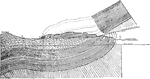
Deflection of Outcrop of Inclined Strata
Models showing deflection of outcrop of dipping strata on sloping surfaces. Slope of valley 40 degrees,…
Deflection of Outcrop of Inclined Strata
Models showing deflection of outcrop of dipping strata on sloping surfaces. Slope of valley 20 degrees,…
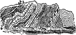
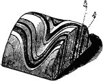
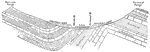
Isoclinal Fold
Isoclinal folds, outcrop of strata in which there is a certain repetition of similar beds, which by…
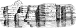
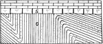
Jointed Rock
This illustration shows a jointed structure. In this drawing, there are two systems of joints or divisional…
Formation of Kettle Holes
Diagrams to illustrate the mode of formation of kettle holes in glacial deposits.
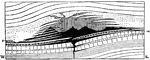
La Plata Mountain
Ideal section of La Plata Mountain, Colorado, showing the supposed original form of the laccolith of…
Laccolite
"Lava has been forced not only into vertical cracks, but also between the layers of stratified rock,…
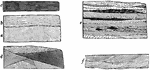
Structure of Layers
"a, the massive; b, the shaly; c, the laminated; d, e, and f, the compound or irregularly bedded." -Dana,…
Limestone Beds
Diagram showing the relationship of the black sapropelitic shales, the oil producers, to the limestone…
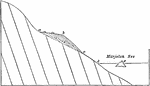
Marjelen Lake
Diagrammatic section of the Marjelen Lake, the Aletsch Glacier which holds it and the valley of the…
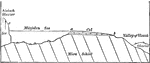
Michigan Basin
Cross-section of the Michigan Basin showing the rimming cuestas which are largely submerged.
Michigan Basin
Cross-section of the Michigan Basin based on well sections. Owing to the exaggeration of the vertical…
Mont Dore, France
Section of the massif of Mont Dore, France, showing the succession of eruptions and the outline of the…
Nashville Dome
Section of the Nashvile dome, showing the center eroded into a topographic basin or encircled lowland,…
New York Peneplane
North-south section across western New York, showing the three cuestas and lowlands and the tilting…
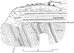
Niagara Escarpment
The edge of the Niagara escarpment. NS, showing the position of the ancient Iroquois Beach (IB) and…
Niagara Falls
This illustration represents a section of the rocks along the river below Niagara Falls. It gives some…
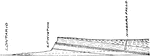
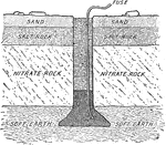
Diagram of Nitrate Bed
The nitrate is found on the east side of a low range of hills from fifteen to ninety miles back from…
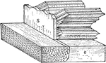
Compound Offlapping and Overlapping Series
Natural and columnar section to illustrate compound offlapping and overlapping series.
Offlaps Followed by Overlap
Section to illustrate the relationships of strata formed by a compound, transgressing, retreatal and…
Oil Accumulation
"Idealized section through a dome showing sand-filled channels in cross-section, points of accumulation…
Ordovician Sandstone and Silurian Limestone
Diagram showing the relationships of the Ordovician sandstones to the Silurian limestones on the Vlightberg…
Ordovician Sandstone and Silurian Limestone
Diagram showing the relationships of the Ordovician sandstones to the Silurian limestones on the Vlightberg…
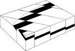
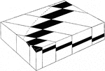
Orographic Blocks
"Unit orographic blocks in granite, near the knife works, Hotchkissville. a Area over downthrown block."…
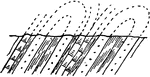
Outcrop Diagram
"Diagram to illustrate crescentic offsetting of outcrops due to progressively increasing tilting of…
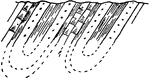
Outcrop Diagram
"Diagram to illustrate crescentic offsetting of outcrops due to progressively increasing throw of orgaraphic…
Outcrop Diagram
"Diagram to illustrate crescentic offsetting of outcrops due to progressive decrease in width of orographic…
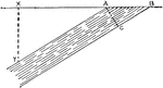
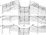
Width of Outcrop
Diagram illustrating width of outcrop AB of the bed, the thickness of which is AC; its depth at X is…
Overlap of Continental Beds
Diagrammatic section to illustrate the overlap of continental beds over a retreatal marine series.
Overlap from the Appalachians to Cincinnati
Restored section from the Appalachians to the Cincinnati region, to show the overlaps of continental…
Various Types of Overlap Across New York State
East-west section across the state of New York, showing the various types of overlap characteristic…
Overlapping Strata
Diagram illustrating the coastal plain of overlapping strata, with consequent and insequent drainage.
Hudson Highlands Overthrust
Diagrammatic section showing the overthrust at the northern end of the Hudson Highlands. The main overthrust…
North Hill Overthrust
Section through North Hill, Kingston, N.Y. showing the overthrust which led to a repetition of the strata.
Paleozoic Rocks
A section of the Paleozoic rocks found in the Mississppi basin illustrating the periods and ages.
Development of a Peneplane
Diagram showing the development of a peneplane from anticlinal ridges and the reappearance of the uniclinal…
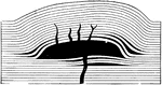
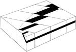
Phacoliths
Diagram illustrating the formation of phacoliths (shown in solid black). A phacolith is an intrusion…
Progressive Offlapping
Section to illustrate the arrangement and change in facies in an offlapping series formed during a retreatal…
Progressive Overlap
Section to show normal progressive overlap of the formations and their shoreward change from muds to…
Progressive Overlap
Sections to illustrate progressive overlap; a) in a continental series, away from the source of supply;…
Progressive Overlap of Marine Formations
Section to show normal progressive overlap of marine formations and their shoreward change from limestones…
Progressive Overlap of Shore
Natural and columnar sections at each end and at the center of a line 100 miles long and at right angles…
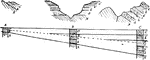
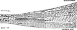
Pulpit Rock Sections
Parallel vertical or columnar sections on the face of Pulpit Rock, near Colorado Springs, through identical…
Replacing Overlap
Diagrammatic section to illustrate replacing overlap of shore or continental sands on the right and…
Rhine Graben
Diagrammatic sections to represent the development of the Rhine Graben and its present structural and…
Rift Valley of the Rhine
Section of the rift valley of the Rhine. 1) granite; 2-7)Mesozoic rocks; 8,9) Tertiary and recent.
New York Rock Formation
Section across Western New York, showing the rock formations exposed on the Niagara River and on the…
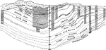
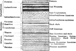
Rock Layers Showing Geological Periods
"Diagrammatic structure section of the Wasatch Range in Ogden Canyon." -Lee, 1915
Rock Layers Showing Types of Rock
"Cross section of Marsh Creek valley at McCammon, Idaho." -Lee, 1915