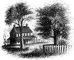
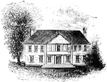
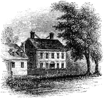
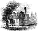
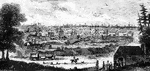
Washington's head-quarters
"Washington's head-quarters. This view is from the Reading rail-road, looking east, and includes a portion…
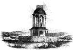
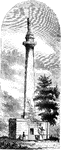
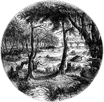
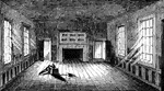
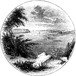
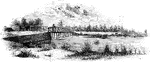
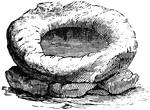
Observatory
"The observatory. This view is from the field, looking north. On the left is seen the winding Schuylkill,…
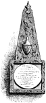
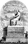
Chatham's Monument
"Chatham's monument, Westminster Abbey. William Pitt, the first Earl of Chatham, was born on the 5th…
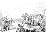
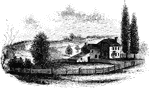
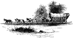
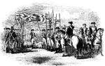
Monmouth
"The field of Monmouth. In the picture here given, the chief is seen most prominently on his white charger,…
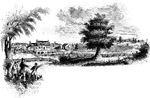
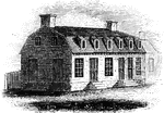
Monmouth Battle-Ground
"Battle-ground at Monmouth. This view is from the orchard, upon the site of Wayne's position when Monckton…
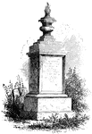
Woodhull's Monument
"Woodhull's Monument. This monument stands on the south side of the church. It is of white marble, about…
Jefferis' Ford
"View at Jefferis' Ford. This view is from the easterly bank of the Brandywine. The ford was at the…
Birmingham Meeting-House
"Birmingham Meeting-house. This is a view of the southerly front of the meeting-house. The building…
Chad's Ford
"View at Chad's Ford. This view is from the east bank of the Brandywine, looking southwest. The ford…
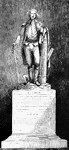
Washington Monument
"Washington Monument. The following are the inscriptions on the monument: East front: 'To George Washington,…
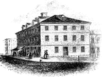
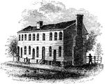
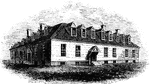
Congress House
"The Congress House. This view is from Baltimore Street, looking southeast. The ront on the left is…
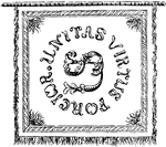
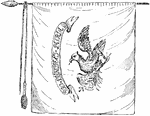
Pulaski's Banner Front
"Pulaski's Banner. On one side of the banner are the letters U. S., and in a circle around them the…
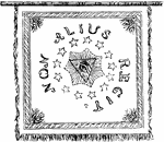
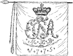
Pulaski's Banner Back
"Pulaski's Banner. On the other side, in the center, is the All-seeing Eye, with the words Non Alius…
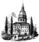
Annapolis State House
"The State House in Annapolis. This fine building is situated upon an elevation in the center of the…
!["Siege of Petersburg- the Ninth Corps charging on the enemy's works after the explosion of the mine, July 30th, 1864. Immediately after the explosion of the mine a hundred cannons opened along the Federal front, and at half-past five the Ninth Corps charged, carrying the fort with a part of the line on each side. The Second Division, which was in the centre, advanced and carried the second line a short distance beyond the fort, and rested, holding ground with the utmost determination. It was at the time the [African American] Division, under General White, was pushed forward and ordered to charge and carry the crest of the hill, which would have decided the contest. The troops advanced in good order as far as the first line, where they received a galling fire, which checked them, and although quite a number kept on advancing, the greater number seemed to become utterly demoralized, part taking refuge in the fort, and the remainder running to the rear as fast as possible. They were rallied and again pushed forward, but without success, the greater part of the officers being killed or wounded."— Frank Leslie, 1896](https://etc.usf.edu/clipart/13900/13915/petersburg_1_13915_mth.gif)
Siege of Petersburg
"Siege of Petersburg- the Ninth Corps charging on the enemy's works after the explosion of the mine,…
!["Siege of Petersburg- the Ninth Corps charging on the enemy's works after the explosion of the mine, July 30th, 1864. Immediately after the explosion of the mine a hundred cannons opened along the Federal front, and at half-past five the Ninth Corps charged, carrying the fort with a part of the line on each side. The Second Division, which was in the centre, advanced and carried the second line a short distance beyond the fort, and rested, holding ground with the utmost determination. It was at the time the [African American] Division, under General White, was pushed forward and ordered to charge and carry the crest of the hill, which would have decided the contest. The troops advanced in good order as far as the first line, where they received a galling fire, which checked them, and although quite a number kept on advancing, the greater number seemed to become utterly demoralized, part taking refuge in the fort, and the remainder running to the rear as fast as possible. They were rallied and again pushed forward, but without success, the greater part of the officers being killed or wounded."— Frank Leslie, 1896](https://etc.usf.edu/clipart/13900/13917/petersburg_2_13917_mth.gif)
Siege of Petersburg
"Siege of Petersburg- the Ninth Corps charging on the enemy's works after the explosion of the mine,…
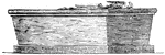
Washington's Bier
"The bier which Washington was carried to the tomb at Mount Vernon."—Lossing, 1851
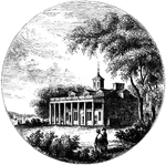
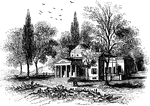
Mount Vernon
"Mount Vernon. This view is from the lawn in front, looking down the Potomac. The mansion is built of…
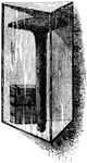
Bastile Key
"Key of the Bastile. This key of the old Paris prison known as the Bastile, was sent by La Fayette to…
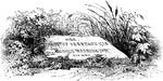
Sarcophagus of Washington
"The sarcophagus of Washington. This was placed in the family vault in the autumn of 1837."—Lossing,…

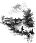
James River
"Scene on the James River, at Richmond. This view is from a long shaded island extending up the river…
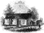
Old City Tavern
"Old City Tavern. This is a frame building, and stands on the northwest corner of Main and Nineteenth…
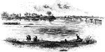
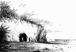
Jamestown Island
"Distant view of Jamestown Island. This view is from the north side of what was once a marsh, but now…
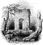
Jamestown Ruins
"Ruins at Jamestown. This view is from the old church-yard, looking toward James River, a glimpse of…
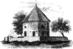
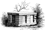
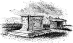
Old Magazine
"The Old Magazine. This view is from the square, looking southeast. South of it is a neat frame building,…
Apollo Room
"The Apollo Room. The room used for public meetings is in the rear building of the old Raleigh tavern…
Raleigh Tavern
"Raleigh Tavern. When I visited Williamsburg in December, 1848, the front part of the old Raleigh tavern…
Boone's Fort
"Boone's Fort. This sketch is from a drawing by Colonel Henderson, and published in Collin's Historical…
Nelson Tombs
"The Nelson Tombs. This view is from the burial-ground looking down the York River toward Chesapeake…
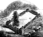
Redoubt
"View from the site of the Redoubt. This view is from the mounds looking northwest, up the York River.…
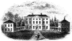
Nelson Mansion
"The Nelson Mansion. This view is from the street looking northwest. A long wooden building, with steep…
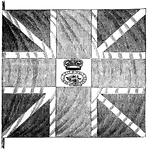
British Flag
"British flag. This is a representation of one of the flags surrendered at Yorktown, and presented to…
Moore's House
"This is a view from the lawn, looking south. It is a frame building with a brick foundation. At the…
Monticello
"Monticello, Governor Jefferson's place of retirement. This venerated mansion is yet standing, though…
William Tryon Seal
"Seal and signature of Tryon. William Tryon was a native of Ireland, and was educated to the profession…
Tryon Palace
"Front view of Tryon's Palace. The view here given was the north front, toward the town. The center…

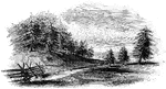
Regulator Battle-ground
"The Regulator battle-ground. This view is from the south side of the Salisbury Road, which is marked…