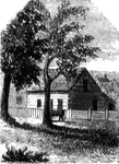
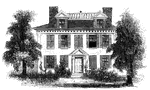
Red House
The Red House. The "Red House" is situated upon the street in Wilkesbarre next the river, and about…
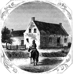
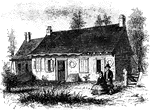
Vankleek House
The Vankleek House. It was built by Myndert Vankleek, one of the first settlers in Dutchess county,…
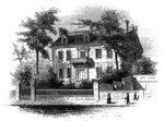
Constitution House
The Constitution House, Kingston. This house, the property and residence of James W. Baldwin, Esq.,…
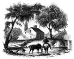
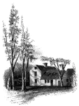
![The Yeoman House. This view is from the road, looking north. An attempt was made by a soldier to burn the house, but so rapid was the march of the invaders that the flames had made but little progress before the troops were far on their road to the village. An [African American] woman, who was concealed under some corn-stalks near, extinguished the flames. The house is about half a mile from the river, on the right side of the road from the landing to Kingston village.](https://etc.usf.edu/clipart/13500/13510/yeoman_13510_mth.gif)
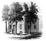
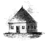
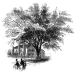
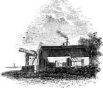
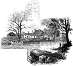
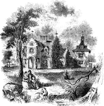
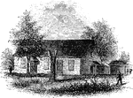
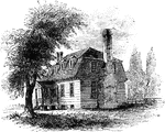
Yeoman House
The Yeoman House. This view is from the road, looking north. An attempt was made by a soldier to burn…
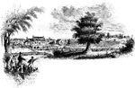
Bennington Battle-ground
The Bennington battle-ground. This view is from the hill on the southwest bank of the Walloomscoick,…
Agnew and Erskine
Head-quarters of Agnew and Erskine. This house is on the south bank of Still River, at the north end…
Ridgefield
Place of the barricade, Ridgefield. This view is at the north end of the main street. It was taken from…
Arnold's residence
Arnold's residence. Arnold lived in Water Street, near the ship-yard. The house is still standing (1848),…
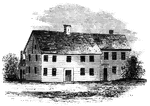
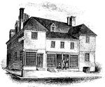
Buckley House
The Buckley House. This building stood upon the eastern side of the Green, fronting the church. It was…
First Meeting House
First meeting hall. This picture of the first house for Christian worship erected in Connecticut is…
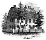
Webb House
The Webb House. This house is still standing (1848), in the central part of Wethersfield, a few rods…
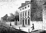
Province House
"The Province House. The Province House, the residence of the colonial governors, is still standing,…
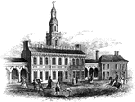
Faneuil Hall
"Faneuil Hall has been denominated 'the cradle of American liberty,' having been the popular gathering-place…
Hancock's House
"Hancock's House, Boston. This is a substantial stone building, situated upon Beacon Street, fronting…
Clark's House
"Clark's House, Lexington. This building was standing when I visited Lexington in 1848. It was built…
Skirmish at Lexington
"Skirmish at Lexington. The largest building in the picture is the meeting-house, and the officer on…
Barrett's House
"Colonel Barrett's House. This sketch is from the road leading to the village of Concord by the way…
Riedesel House
"The Riedesel House, Cambridge. This is from a pencil sketch by Mr. Longfellow. I am also indebted to…
Washington Elm
"The Washington Elm. The horse seen in this sketch is one of the oldest in Cambridge, having been built…
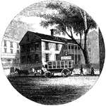
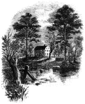
Providence Tavern
"Old Tavern in Providence. This view is from the market, looking north. The building stands on the east…
Hubbard's House and Mill
"Hubbard's House and Mill. The inscriptions upon the monument are as follows: East Side: "Oliver Hazard…
Prescott's Headquarters
"Prescott's Headquarters. This house is on the east side of the west road, about a mile from the bay.…
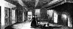
Dining-Hall
"The dining-hall, or room with seven doors. In the December number of the New York Mirror for 1834,…
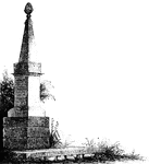
Goshen Monument
"Monument at Goshen. During the battle, Major Wood, of Goshen, made a masonic sign, by accident, which…
Greene and Knox Head-Quarters
"Head-quarters of Greene and Knox. This view is from the turnpike road, looking southeast. The water…

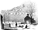
Mrs. Falls'
"Mrs. Falls'. This house, now (1850) owned by Mr. Samuel Moore, is a frame building, and stands on the…
Smith's House
"Smith's House. This view is from the slope in front of the house. The main building is of stone; the…
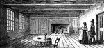
Breakfast Room
"The Breakfast Room. This is a view of the room in the Robinson House in which Arnold was at breakfast…
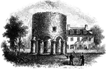
Stony Point
"Rear view at Stony Point. This sketch presents a rear view of the old embankments of the fort, and…
Sunnyside
"View of 'Sunnyside,' the residence of Washington Irving. Built by Wolfert Ecker and known famously…
Tappan head-quarters
"Washington's head-quarters at Tappan. This view is from the yard, near the well. The date of its erection…
Hopper House
"The Hopper House. This view is from the road, looking northeast. The low part, on the left, is a portion…
Friends' meeting-house
"Friends' meeting-house. This view is from the shed in the yard, looking southeast. The building stands…
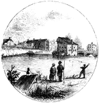
Trenton
"Trenton Bridge and vicinity. This view is from the north side of the Assanpink, a few rods above the…
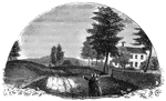
Princeton battle-ground
"View of the battle-ground near Princeton. This view, looking north, is from the carriage gate of Mr.…
Carpenters' Hall
"Carpenters' Hall. This building is constructed of small imported bricks, each alternate one glazed,…
State House
"Walnut Street front of the State House in 1776. This gives the appearance of the shorter steeple, which…
Penn's House
"Penn's House. This view is from Second Street. The building is of imported brick, except the modern…
Howe's Quarters
"General Howe's quarters were in a house on High Street, one door east from the southeast corner of…
Monmouth Battle-Ground
"Battle-ground at Monmouth. This view is from the orchard, upon the site of Wayne's position when Monckton…
Birmingham Meeting-House
"Birmingham Meeting-house. This is a view of the southerly front of the meeting-house. The building…
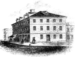
Congress House
"The Congress House. This view is from Baltimore Street, looking southeast. The ront on the left is…
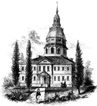
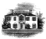
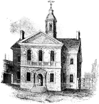
Annapolis State House
"The State House in Annapolis. This fine building is situated upon an elevation in the center of the…
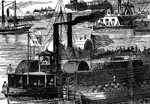
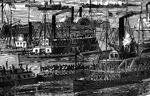
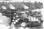
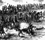
Burning of the White House
"Burning of the White House- the Federal troops, by command of General McClellan, abandoning their position…
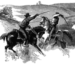
Old Church
"Desperate skirmish at Old Church, near Tunstall's Station, VA., between a squadron of the Fifth United…
Old Church
"Desperate skirmish at Old Church, near Tunstall's Station, VA., between a squadron of the Fifth United…
Grafton Occupied by Federal Troops
"View of Grafton, West Virginia, occupied by the Federal Troops, under the command of General McClellan,…
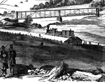
Railroad at Grafton
"View of Grafton, West Virginia, occupied by the Federal Troops, under the command of General McClellan,…
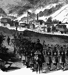
Federal Troops at Grafton, West Virginia
"View of Grafton, West Virginia, occupied by the Federal Troops, under the command of General McClellan,…
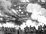
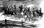
Battle of White Oak Swamp Bridge
"Battle of White Oak Swamp Bridge, Monday June 30th, 1862- Ayres's, Mott's and Randall's batteries checking…
Battle of White Oak Swamp Bridge
"Battle of White Oak Swamp Bridge, Monday June 30th, 1862- Ayres's, Mott's and Randall's batteries checking…
Battle of White Oak Swamp Bridge
"Battle of White Oak Swamp Bridge, Monday June 30th, 1862- Ayres's, Mott's and Randall's batteries checking…
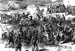
Battle of White Oak Swamp Bridge
"Battle of White Oak Swamp Bridge, Monday June 30th, 1862- Ayres's, Mott's and Randall's batteries checking…
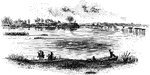
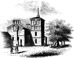
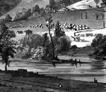
Jamestown Island
"Distant view of Jamestown Island. This view is from the north side of what was once a marsh, but now…
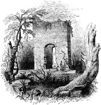
Jamestown Ruins
"Ruins at Jamestown. This view is from the old church-yard, looking toward James River, a glimpse of…
Moore's House
"This is a view from the lawn, looking south. It is a frame building with a brick foundation. At the…