|
|
|
| Maps > United States > Civil War |
A collection of historic maps of the American Civil War, including regional seats of the war, battle and campaign maps, and territories held by Confederate and Union forces.
|
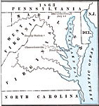
Territory held by the Confederates at the close of 1863,
1863 |
|
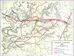
Vicksburg Campaign,
1863 |
|
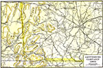
Gettysburg Campaign,
1863 |

|
Battle of Chickamauga,
1863 |
|
Battle of Gettysburg,
1863 |
|
Positions of Armies,
1863 |
|
Battle of Gettysburg,
1863 |

|
Grant's Road to Vicksburg,
1863 |
|
State Secessions,
1863 |

|
Richmond and Vicinity,
1863 |
| First | Previous | Next | Last |
| Maps > United States > Civil War |
Maps ETC is a part of the Educational Technology Clearinghouse
Produced by the Florida Center for Instructional Technology © 2009
College of Education, University of South Florida