Record
71 to
80 of
121
Historic and contemporary maps of Europe, including physical and political maps, early history and empires, WWI maps, climate maps, relief maps, vegetation maps, population density and distribution maps, cultural maps, and economic/resource maps.
|
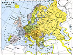
Europe,
1910
Map of Europe in 1910. Map is color–coded to distinguish between various countries. ...
|
|
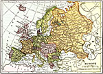
Europe,
1912
Map of Europe in 1912 showing political boundaries, cities, waterways, and railways....
|

|
Language Map of Europe,
1914–1918
This map shows the divisions of language usage in World War I era Europe. Many of these languages fall into the Indo–European language family, the largest language family in the world. This family includes German, Greek, Italian, English, Frenc...
|

|
Europe,
1914–1919
Map of Europe showing borders and boundaries after World War I. ...
|
|
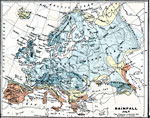
Rainfall in Europe - July,
1915
A map from 1915 of Europe showing mean rainfall distribution throughout the region in July, given in inches of precipitation. The map is color–coded to show the areas of sparse, moderate, and heavy rainfall....
|
|
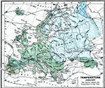
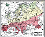
Temperature in Europe - January,
1915
A 1915 map showing averaged temperature isolines throughout Europe in January measured in degrees Fahrenheit. The map shows large bodies of water and landforms that effect temperatures in Europe, including the Atlantic, Mediterranean, North Sea, Blac...
|
|
Temperature in Europe - July,
1915
A 1915 map showing averaged temperature isolines throughout Europe in July measured in degrees Fahrenheit and color–coded to show areal temperatures ranging from 50 to above 80 degrees. The map shows large bodies of water and landforms that eff...
|
|
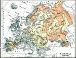
Rainfall in Europe - January,
1915
A climatic map of Europe showing the average rainfall for the area in January measured in inches. Since rainfall in January is rare at the higher Latitudes, the figures should be taken to represent precipitation equivalents. The map also shows the cl...
|
|
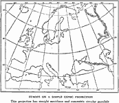
Europe On a Conic Projection,
1915
A map of Europe on a simple conic projection showing straight meridians or lines of longitude, and concentric circular parallels or lines of latitude....
|
|
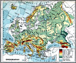
Orographical Map of Europe,
1915
A map from 1915 of Europe showing general land elevations above and below sea level throughout the region, mountain systems, plateaus, and plains....
|
Maps ETC is a part of the Educational Technology Clearinghouse
Produced by the Florida Center for Instructional Technology © 2009
College of Education, University of South Florida