Maps Site map
  Maps > United States > Agriculture
Site Map  

  Record   131   to   140  of   141

A collection of agricultural production and agricultural related maps in the United States for use in the K-12 classroom.

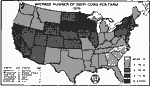
Average Number of Dairy Cows per Farm, 1920
A map of the United States from the U. S. Department of Agriculture (1922) showing the average number of dairy cows per farm by state in 1920....

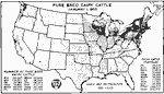
Pure Bred Dairy Cattle, 1920
A map of the United States from the U. S. Department of Agriculture (1922) showing the number of pure bred dairy cattle in each state on January 1, 1920....

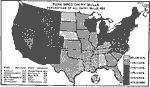
Pure Bred Dairy Bulls, 1920
A map of the United States from the U. S. Department of Agriculture (1922) showing the percentage of bulls per state that were pure bred dairy bulls in 1920....

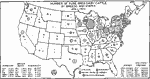
Number of Pure Bred Dairy Cattle by Breeds and States, 1920
A map of the United States from the U. S. Department of Agriculture (1922) showing the number of pure bred dairy cattle by breeds and states on January 1, 1920....

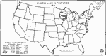
Cheese Made in Factories, 1921
A map of the United States from the U. S. Department of Agriculture (1922) showing the distribution of factory–produced cheese production by state in 1921. "Practically all the cheese is now made in factories, only 6,000,000 pounds in 1919...

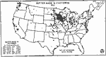
Butter Made in Factories, 1921
A map of the United States from the U. S. Department of Agriculture (1922) showing butter production in factories by state in 1921....

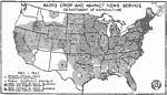
Radio Crop and Market News Service, 1922
A map of the United States from the U. S. Department of Agriculture (1922) showing the radio broadcast coverage areas for crop and market news reports as of December 1, 1922....

Licensed Tobacco Inspectors, Graders, and Weighers, 1922
A map of the eastern United States from the U. S. Department of Agriculture (1922) showing the number of licensed tobacco inspectors, graders and weighers at the time. The size of the circles is proportionate to the number of inspectors, graders and ...

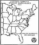
Licensed Tobacco Storage Warehouses, 1922
A map of the eastern United States from the U. S. Department of Agriculture (1922) showing the number of licensed tobacco storage warehouses at the time. Each dot represents one warehouse....

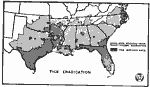
Cattle Tick Quarantine Area in the South, 1922
A map of the United States from the U. S. Department of Agriculture (1922) showing zones of quarantine for infestation of cattle ticks and areas released from this quarantine in the South in 1922....

First Previous Next Last


  Maps > United States > Agriculture
Site Map  

Maps ETC is a part of the Educational Technology Clearinghouse
Produced by the Florida Center for Instructional Technology © 2009
College of Education, University of South Florida