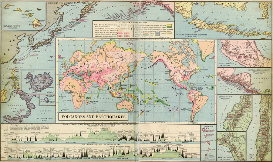
Description: This map from 1890 shows areas of volcanic and seismic activity throughout the world. Areas of particular interest are shown on a larger scale. The world map shows volcanoes grouped in lines along mountain ranges with a heavy black line, and volcanoes not associated with any considerable mountain chains with a cross. The map is color-coded to show regions not visited by earthquakes in orange, and regions subject to seismic disturbances in pink, with the more frequent reoccurrence of shocks indicated by the greater depth of color. Land elevated in recent geologic periods, or now rising, is shown in dark yellow, land which has subsided in recent periods, or now sinking, is shown in dark green. On the special maps the different countries or grand divisions to which volcanic groups or systems belong are colored as North America (light pink), South America (light green), Europe (light purple), Asia (light brown), and Oceania (light yellow). The names of volcanoes, geysers, et cetera, are underlined in red. The special maps include the Hawaiian group of volcanoes, the northern and western Pacific groups of volcanoes, the central part of the Sunda Islands (Indonesia) group, Mexican group, Central American group, Quito group, Chilean group, Peruvian group, Lesser Antilles group, and the volcanoes of lower Italy, Iceland, and Santorini. This map includes two diagrams showing the relative altitude in feet above sea level of the principal volcanoes of the world, with volcanoes of the Central Belt in the upper diagram, the volcanoes skirting the Pacific Ocean in the lower diagram. The black peaks represent volcanoes; the green peaks are of non-volcanic origin. The mountains in the upper diagram are those which extend along a line of volcanic action running eastward from Iceland across Europe, Asia, and the Sunda Islands to the Mexican Plateau and the Antilles. Those in the lower diagram belong to the great volcanic systems which skirt the shores of the Pacific Ocean (Ring of Fire).
Place Names: A Complete Map of Globes and Multi-continent, Africa, �Antarctica, �Asia, �Australia, �Europe, �North America, �South America, �Hawaii, �Japan, �Borneo, �Iceland, �Italy, �Alaska, �Sumatra, �Indonesia, �Java, �Mexico, �Peru, �Chile, �Ecuador, �Guadeloupe, �Dominica, �Martinique, �St. Lucia, �St. V
ISO Topic Categories: boundaries,
elevation,
environment,
geoscientificInformation
Keywords: Volcanoes and Earthquakes, physical, �earthquakes, �volcanoes, �physical features,
topographical,
geological, boundaries,
elevation,
environment,
geoscientificInformation, Unknown, 1890
Source: William H. Brewer Ph.,D., Warren's New Physical Geography (Philadelphia, PA: Cowperthwait and Company, 1890) 22-23
Map Credit: Courtesy the private collection of Roy Winkelman |
|