Search Results: Displaying records 61 through 80 of 80 records found. |
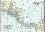 |
Central America 1920 A map from 1920 of Central America showing political boundaries at the time, capitals and major cities, railroads, submarine telegraph cables, mountain systems, lakes, rivers, coastal features, banks or reefs, and the islands of Jamaica and Grand Cay... |
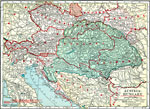 |
Austria-Hungary 1920 A map of Austria–Hungary in 1920, showing railroads, canals, and submarine telegraph lines. This map shows the partition of the Austro–Hungarian territories after WWI, showing the new boundaries established by the Treaty of Saint Germaine... |
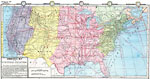 |
Commercial Map of the United States 1872 A commercial map from 1872 of the United States showing the principal railroad and steamship routes in the region at the time. The map shows state boundaries and capitals, major cities and ports, submarine telegraph cables to Europe, rivers, mountain... |
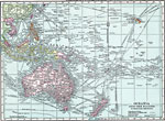 |
Oceana and the Pacific 1920 A map from 1920 of Oceania and the Pacific between latitudes 30° N and 50° S, and longitudes 100° E and 140° W of Greenwich. This map is drawn on a Mercator's Projection, and shows cities and ports, ocean steamer routes with distances ... |
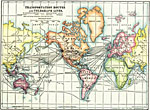 |
Transportation Routes and Telegraph Lines 1918 Shows transcontinental railways, steamship routes, telegraph lines, and cables.... |
 |
Northern Territory 1920 A map of Australia's Northern Territory in 1920 showing cities, railway, and the route of the overland telegraph, as well as rivers, lakes, mountains, and coastal features.... |
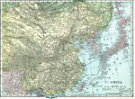 |
China 1920 A map from 1920 of China and the Empire of Japan at the time. The map shows political boundaries and foreign possessions, capitals, provincial capitals, major cities, treaty ports, existing and proposed railroads, canals, submarine telegraph cables, ... |
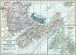 |
Maritime Provinces of Canada 1920 A map from 1920 of the Canadian Maritime Provinces of New Brunswick, Nova Scotia, and Prince Edward Island, with an inset map of Newfoundland. The map shows the county boundaries within the provinces, the provincial capitals of Fredericton (New Bruns... |
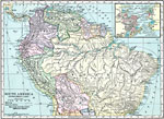 |
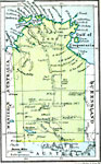
Northern South America 1920 A map from 1920 of the northern part of South America from the Caribbean Sea south the Rio de Janeiro. The map shows the political boundaries at the time for Panama, Columbia, Venezuela, British, Dutch, and French Guiana, Ecuador, Peru, and Bolivia, ... |
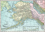 |
Alaska 1920 A map of Alaska from 1920 showing the State capital at Juneau, cities, towns, ports, railroads, overland and submarine telegraph lines, major rivers and mountains, coastal features, and islands. The map has inset maps detailing the areas of the south... |
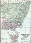 |
New South Wales, Victoria, and Tasmania 1920 A map of New South Wales, Victoria, and Tasmania in 1920 showing counties, cities, ports, railroads, cables and major overland telegraph lines, rivers, mountains, and coastal features. ... |
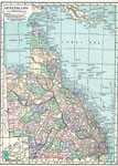 |
Queensland 1920 A map of Queensland, Australia in 1920, showing counties, cities and ports, railways, submarine cable and important overland telegraph routes, rivers, lakes, mountains, and coastal features. The map shows the Great Barrier Reef and Torres Straight be... |
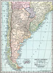 |
Southern South America 1920 A map from 1920 of the southern part of South America from Sao Paulo on the Atlantic and Iquique on the Pacific south to Tierra del Fuego. The map shows the political boundaries at the time for Argentina, Paraguay, Uruguay, and the southern portions ... |
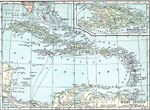 |
West Indies 1920 A map from 1920 of the Greater and Lesser Antilles, and the Bahama Island group, showing capitals, major cities, towns and ports, railroads, submarine telegraph routes, terrain, and coastal features. The foreign possessions in the region are indicate... |
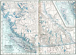 |
Southern British Columbia 1922 A map from 1922 of the southern part of British Columbia showing the provincial capital of Victoria, major cities and towns, existing and proposed railroads, telegraph lines and submarine cables, mountains, lakes, rivers, coastal features, and island... |
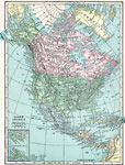 |
North America 1920 A map from 1920 of North America, Central America, Greenland, and Caribbean showing national, state, and province boundaries, capitals and major cities, railroads, submarine telegraph cables, mountain systems, rivers, and coastal features. Inset maps... |
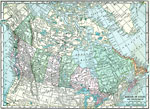 |
The Dominion of Canada and Newfoundland 1920 A map from 1920 of the Dominion of Canada and Newfoundland (Newfoundland and Labrador were not part of the Canadian Confederation until 1949), showing the provinces at the time, provincial capitals, major cities, towns, and settlements, railways, sub... |
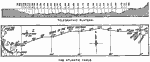 |
Atlantic Telegraph Cable 1890 Track of the Trans–Atlantic Telegraph Cable of 1865.... |
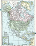 |
North America 1920 A map from 1920 of North America, Central America, Greenland, and Caribbean showing national, state, and province boundaries, capitals and major cities, railroads, submarine telegraph cables, mountain systems, rivers, and coastal features. Inset maps... |
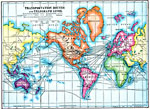 |
Transportation Routes and Telegraph Lines 1910 A map from 1910 showing the location of then–current transcontinental railway and steamship transportation routes, submarine cables, and telegraph lines in the world. The map also shows the International Date Line.... |
| New Search | [First Page] [Previous] 1 2 3 4 |
Maps ETC is a part of the Educational Technology Clearinghouse. Produced by the Florida Center for Instructional Technology, College of Education, University of South Florida. © 2009—2026.