Search Results: Displaying records 21 through 40 of 80 records found. |
 |
North America 1858 A map from 1858 of North America showing the boundaries at the time for Russian America (Alaska), Greenland, British America or New Britain, Canada East and Canada West, the United States, Mexico, Central America, and the West Indies Islands. The map... |
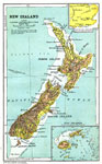 |
New Zealand 1904 A geo–political map of New Zealand current to 1904, showing major cities, railroad lines, and navigable rivers. Physical features include mountain ranges with elevation measured in feet, major rivers and watersheds, and the 100–fathom lin... |
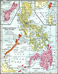 |
Philippine Islands 1906 A map from 1906 of the Philippine Islands, showing the province boundaries at the time, the capital in Manila and other major cities, railways, terrain, rivers, and coastal features of the island group. The map includes an inset of the island of Guam... |
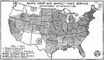 |
Radio Crop and Market News Service 1922 A map of the United States from the U. S. Department of Agriculture (1922) showing the radio broadcast coverage areas for crop and market news reports as of December 1, 1922.... |
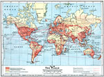 |
Principal Transportation Lines and Commercial Development of the World 1916 A world map from 1916, showing principal transportation lines and levels of commercial development at the time. The map is color–coded to show commercially developed regions, regions partially developed or capable of becoming commercially devel... |
 |
Map of The World on Mercator's Projection 1918 This is a map of the world from 1918 showing the earth on a Mercator's Projection. This map is color–coded to show the colonial possessions of Great Britain, France, Germany, Portugal, Spain, Netherlands, Italy, Denmark, and the United States i... |
 |
Map of Great Britain and Ireland 1852 A map of the British Isles from 1852 showing Ireland, Scotland, England, and Wales. This map shows major cities, railroads, canals, universities, rivers, and terrain. Map notations indicate sailing distances measured in miles between the islands and ... |
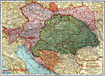 |
Austria-Hungary 1920 A map of Austria–Hungary in 1920, showing railroads, canals, and submarine telegraph lines. This map shows the partition of the Austro–Hungarian territories after WWI, showing the new boundaries established by the Treaty of Saint Germaine... |
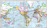 |
The World 1901 A map from 1901 of the world showing colonial possessions at the time, principal steamship routes, and submarine cables and telegraph lines. The map is color–coded to show the possessions of Great Britain, France, Germany, Portugal, Spain, Neth... |
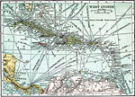 |
West Indies 1920 A map from 1920 of the Greater and Lesser Antilles, and the Bahama Island group, showing capitals, major cities, towns and ports, railroads, steamship routes, submarine telegraph routes, terrain, and coastal features. The foreign possessions in the r... |
 |
British Isles 1912 A black and white map of the British Isles in 1912, showing cities, waterways, mountain ranges, railroads, and submarine cables.... |
 |
Territories, Telegraph Cables, and Ocean Routes of the World 1912 A map of the world from 1912 showing telegraph cables, principal ocean routes with distances between ports given in nautical miles, and the colonies, territories, and possessions of the United States, Great Britain, Germany, France, Italy, Netherland... |
 |
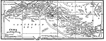
Central America 1912 A black and white map from 1912 of Central America showing political boundaries at the time, capitals and major cities, railroads, submarine telegraph cables, mountain systems, lakes, rivers, coastal features, banks or reefs, and the islands of Jamai... |
 |
British Columbia 1912 A map from 1912 of British Columbia showing the provincial capital of Victoria, major cities and towns, existing and proposed railroads, telegraph lines and submarine cables, mountains, lakes, rivers, coastal features, and islands.... |
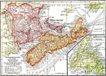 |
The Maritime Provinces of Canada With Insert Map of Newfoundland 1912 A map from 1912 of the Maritime Provinces of Canada, including New Brunswick, Nova Scotia, and Prince Edward Island. The map shows the provincial capitals of Fredericton (New Brunswick), Halifax (Nova Scotia), and Charlottetown (Prince Edward Island)... |
 |
West Indies 1914 A map from 1914 of the West Indies and the Bahama Island group, showing capitals, major cities, towns and ports, railroads, main steamship routes, submarine telegraph routes, terrain, and coastal features. The foreign possessions in the region are in... |
 |
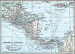
Central America 1922 A map from 1922 of Central America showing political boundaries at the time, capitals and major cities, railroads, submarine telegraph cables, mountain systems, lakes, rivers, coastal features, banks or reefs, and the islands of Jamaica and Grand Cay... |
 |
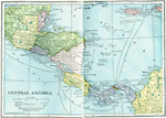
Central America 1914 A map from 1914 of Central America showing political boundaries at the time, capitals and major cities, railroads, steamship routes with distances between major ports given in nautical miles, submarine telegraph cables, mountain systems and terrain, ... |
 |
Central America 1919 A map from 1919 of Central America showing political boundaries at the time, capitals and major cities, railroads, submarine telegraph cables, mountain systems, lakes, rivers, coastal features, banks or reefs, and the islands of Jamaica and Grand Cay... |
 |
Cuba 1912 A black and white map from 1912 of Cuba showing the provinces and provincial capitals, major cities and towns, railroads, submarine telegraph cable routes, rivers, terrain and coastal features, reefs, and smaller neighboring islands.... |
| New Search | [First Page] [Previous] 1 2 3 4 [Next] [Last Page] |
Maps ETC is a part of the Educational Technology Clearinghouse. Produced by the Florida Center for Instructional Technology, College of Education, University of South Florida. © 2009—2026.