Search Results: Displaying records 1 through 20 of 80 records found. |
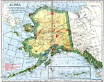 |
Alaska 1919 A map of Alaska from 1914 showing the State capital at Juneau, cities, towns, ports, railroads, submarine telegraph lines, major rivers and lakes, mountains, coastal features, and islands. The map is keyed to show gold placers, gold and silver mines ... |
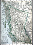 |
British Columbia 1909 A map from 1909 of British Columbia showing the provincial capital of Victoria, major cities and towns, existing and proposed railroads, telegraph lines and submarine cables, mountains, lakes, rivers, coastal features, and islands.... |
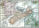 |
The Maritime Provinces of Canada - New Brunswick, Nova Scotia, Prince Edward Island 1909 A map from 1909 of the Maritime Provinces of Canada, including New Brunswick, Nova Scotia, and Prince Edward Island. The map shows the provincial capitals of Fredericton (New Brunswick), Halifax (Nova Scotia), and Charlottetown (Prince Edward Island)... |
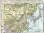 |
China 1920 A map from 1920 of China and the Empire of Japan at the time. The map shows political boundaries and foreign possessions, capitals, provincial capitals, major cities, treaty ports, existing and proposed railroads, canals, submarine telegraph cables, ... |
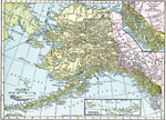 |
Alaska 1920 A map of Alaska from 1920 showing the State capital at Juneau, cities, towns, ports, railroads, overland and submarine telegraph lines, major rivers and mountains, coastal features, and islands. The map has inset maps detailing the areas of the south... |
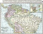 |
Northern Part of South America 1920 A map from 1920 of the northern part of South America from the Caribbean Sea south the Rio de Janeiro. The map shows the political boundaries at the time for Panama, Columbia, Venezuela, British, Dutch, and French Guiana, Ecuador, Peru, and Bolivia, ... |
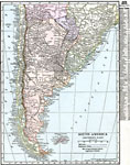 |
South America (Southern Part) 1920 A map from 1920 of the southern part of South America from Sao Paulo on the Atlantic and Iquique on the Pacific south to Tierra del Fuego. The map shows the political boundaries at the time for Argentina, Paraguay, Uruguay, and the southern portions ... |
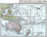 |
Oceania and the Pacific on Mercator's Projection 1920 A map from 1920 of Oceania and the Pacific on a Mercator's Projection between latitudes 30° N and 50° S, and longitudes 100° E and 140° W of Greenwich. This map shows cities and ports, ocean steamer routes with distances between major ... |
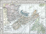 |
The Maritime Provinces of Canada 1920 A map from 1920 of the Maritime Provinces of Canada, including New Brunswick, Nova Scotia, and Prince Edward Island. The map shows the county divisions and capitals, the provincial capitals of Fredericton (New Brunswick), Halifax (Nova Scotia), and C... |
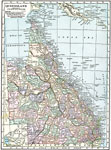 |
Queensland 1920 A map of Queensland, Australia in 1920, showing counties, cities and ports, railways, submarine cable and important overland telegraph routes, rivers, lakes, mountains, and coastal features. The map shows the Great Barrier Reef and Torres Straight be... |
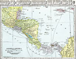 |
Central America 1920 A map from 1920 of Central America showing political boundaries at the time, capitals and major cities, railroads, submarine telegraph cables, mountain systems, lakes, rivers, coastal features, banks or reefs, and the islands of Jamaica and Grand Cay... |
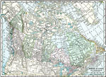 |
The Dominion of Canada and Newfoundland 1920 A map from 1920 of the Dominion of Canada and Newfoundland (Newfoundland and Labrador were not part of the Canadian Confederation until 1949), showing the provinces at the time, provincial capitals, major cities, towns, and settlements, railways, sub... |
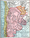 |
Argentine Republic, Chile, Paraguay, and Uruguay 1904 A map from 1904 of the Argentine Republic, Chile, Paraguay, and Uruguay. This map shows capital cities, major towns, ports, rivers, terrain, and coastal features. The map shows mean annual temperatures for selected cities, elevations for major peaks ... |
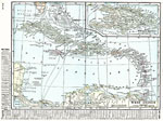 |
West Indies 1920 A map from 1920 of the Greater and Lesser Antilles, and the Bahama Island group, showing capitals, major cities, towns and ports, railroads, submarine telegraph routes, terrain, and coastal features. The foreign possessions in the region are indicate... |
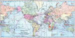 |
Commercial Map of the World showing the Chief Countries and their Possessions 1899 A map of the world from 1899, color–coded to show the chief countries of the world and their possessions at the time, including the United States, Great Britain, Germany, France, Italy, Spain, Portugal, Denmark, and Netherlands. The map shows m... |
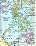 |
Philippine Islands 1920 A map from 1920 of the Philippine Islands, showing the province boundaries at the time, the capital of Manila and other major cities, railways, terrain, rivers, and coastal features of the island group. The map is color–coded, breaking the isla... |
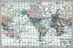 |
The World 1910 A world map from 1901 showing the International Date Line, submarine telegraph cables and oceanic steamship routes with distances between major ports. The map is color–coded to show the territorial possessions of the United States, Great Britai... |
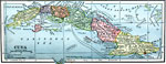 |
Cuba 1909 A map from 1909 of Cuba and the Isle of Pines showing the provinces and provincial capitals, major cities and towns, railroads, submarine telegraph cable routes, rivers, terrain and coastal features, reefs, and smaller islands.... |
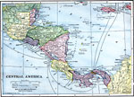 |
Central America 1909 A map from 1909 of Central America showing political boundaries at the time, capitals and major cities, railroads, submarine telegraph cables, mountain systems, lakes, rivers, coastal features, banks or reefs, and the islands of Jamaica and Grand Cay... |
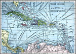 |
West Indies 1909 A map from 1909 of the West Indies and the Bahama Island group, showing capitals, major cities, towns and ports, railroads, steamship routes, submarine telegraph routes, terrain, and coastal features. The foreign possessions in the region are indicat... |
| New Search | 1 2 3 4 [Next] [Last Page] |
Maps ETC is a part of the Educational Technology Clearinghouse. Produced by the Florida Center for Instructional Technology, College of Education, University of South Florida. © 2009—2026.