Search Results: Displaying records 41 through 60 of 80 records found. |
 |
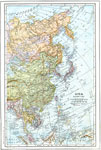
China 1920 A map from 1920 of China and the Empire of Japan at the time. The map shows political boundaries and foreign possessions, capitals, provincial capitals, major cities, treaty ports, existing and proposed railroads, canals, submarine telegraph cables, ... |
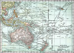 |
Oceania and the Pacific 1920 A map from 1920 of Oceania and the Pacific on a Mercator's Projection between latitudes 30° N and 50° S, and longitudes 100° E and 140° W of Greenwich. This map shows cities and ports, ocean steamer routes with distances between major ... |
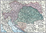 |
Austria-Hungary 1919 A map of Austria–Hungary in 1919, showing cities, submarine telegraph lines, canals, and railroads.... |
 |
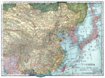
Eastern Asia 1914 A map from 1914 of East Asia showing the political boundaries of the time, including the Asian portion of the Russian Empire, the Chinese Empire, Korea, the Empire of Japan, and the foreign possessions of Britain, France, Netherlands, and the United ... |
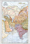 |
Western Asia 1914 A map from 1914 of the western portion of Asia, including western Siberia and Russian Turkestan, Turkey in Asia, the Arabian Peninsula, Oman, Persia, Afghanistan, portions of Chinese Turkestan and Tibet, Nepal, and the British possessions in India fr... |
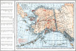 |
Alaska 1914 A map of Alaska from 1914 showing the State capital at Juneau, cities, towns, ports, railroads, overland and submarine telegraph lines, mineral mines, major rivers and mountains, coastal features, and islands. A grid reference in the left margin of t... |
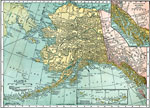 |
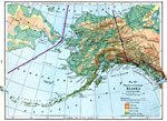
Alaska 1920 A map of Alaska from 1920 showing the State capital at Juneau, cities, towns, ports, railroads, overland and submarine telegraph lines, major rivers and mountains, coastal features, and islands. The map has inset maps detailing the areas of the south... |
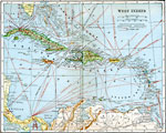 |
The West Indies 1920 The West Indies, showing the countries as well as steamer routes, submerged telegraph cables, and railroads.... |
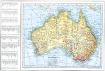 |
Australia 1914 A map of Australia in 1914 showing states, territories, and divisions, major towns and cities, rivers, mountains, railways, overland telegraph routes, submarine cables, and steamship routes. This map also has a list of principle cities and towns of A... |
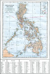 |
Philippine Islands 1914 A map from 1914 of the Philippine Islands. The map shows the major islands and surrounding seas, cities, towns, and ports, railroads, submarine telegraph cables to Hong Kong, Guam, San Francisco, and through the islands, province boundaries at the ti... |
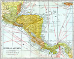 |
Central America 1920 The countries of Central America, showing country borders, steamship routes, and telegraph lines.... |
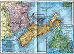 |
Maritime Provinces of Canada 1922 A map from 1922 of the Canadian Maritime Provinces of New Brunswick, Nova Scotia, and Prince Edward Island, with an inset map of Newfoundland. The map shows the provincial capitals of Fredericton (New Brunswick), Halifax (Nova Scotia), and Charlottet... |
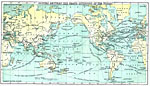 |
Steamship and Telegraph Routes Between the Grand Divisions of the World 1888 A world map from 1888 showing principal steamship routes, telegraph (operational and proposed), and submarine telegraph cable routes at the time.... |
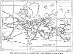 |
World Railway, Steamship and Submarine Telagraph Cable Routes 1915 A world map from 1915 showing principal railways, steamship routes with distances between ports given in nautical miles, and submarine telegraph cable routes at the time.... |
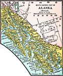 |
South Eastern Part of Alaska 1920 A map of the southeastern part of Alaska from 1920 showing the State capital at Juneau, Sitka and other towns, submarine telegraph cables, rivers, islands, and fjords of the area, and the undefined border with Canada.... |
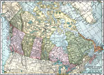 |
The Dominion of Canada and Newfoundland 1920 A map from 1920 of the Dominion of Canada and Newfoundland (Newfoundland and Labrador were not part of the Canadian Confederation until 1949), showing the provinces at the time, provincial capitals, major cities, towns, and settlements, railways, sub... |
 |
Alaska 1916 A map of Alaska from 1919 showing the State capital at Juneau, cities, towns, ports, railroads, overland and submarine telegraph lines, major rivers and mountains, coastal features, and islands. The map uses color–contouring to show elevations ... |
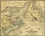 |
New Brunswick, Nova Scotia and Newfoundland 1858 A map from 1858 of New Brunswick, Nova Scotia and Newfoundland, which surround the Gulf of St. Lawrence. The map shows major cities and ports, rivers, and coastal features. The figures attached to Cities and Towns indicate the number of thousands of ... |
 |
Commerce and Trade World Map 1872 A world map from 1872 showing trade routes by steamship, sailing vessel, and railway, and primary exports for various countries at the time. Red lines on water show steamer routes, brown lines show sailing routes, red lines on land show railroads, bl... |
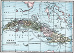 |
Cuba 1919 A map from 1919 of Cuba and the Isle of Pines showing the provinces and provincial capitals, major cities and towns, railroads, submarine telegraph cable routes, rivers, terrain and coastal features, reefs, and smaller islands. The map shows the prox... |
| New Search | [First Page] [Previous] 1 2 3 4 [Next] [Last Page] |
Maps ETC is a part of the Educational Technology Clearinghouse. Produced by the Florida Center for Instructional Technology, College of Education, University of South Florida. © 2009—2024.