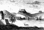
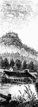
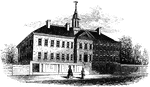
West Point
"West Point in 1780. This view is from a print published in the New York Magazine for 1790.…
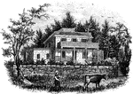
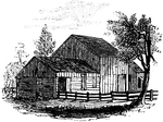
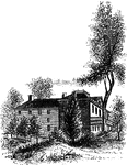
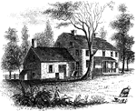
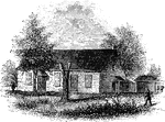
Smith's House
"Smith's House. This view is from the slope in front of the house. The main building is of stone; the…
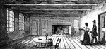
Breakfast Room
"The Breakfast Room. This is a view of the room in the Robinson House in which Arnold was at breakfast…
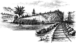
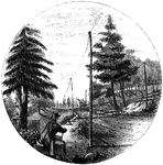
Beverly Dock
"View at Beverly Dock. This view is taken from the Hudson River rail-road, looking north. The dock,…
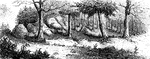
Fort Montgomery
"View near Fort Montgomery. This view is from an eminence near the mountain road, about three quarters…
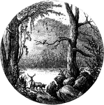
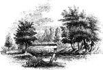
Lake Sinnipink
"Lake Sinnipink, or Bloody Pond. This view is from the outlet of the lake, within a few rods of the…
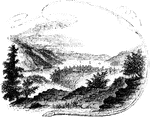
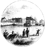
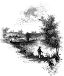
Peekskill Landing
"View from Peekskill Landing. This view is from Peekskill landing, looking up the river. On the left…
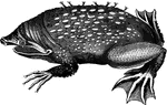
Surinam toad
"At the breeding season the back of the female exhbits a number of small pits; into these pits the male…
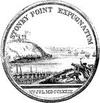
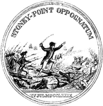
Stony Point
"Rear view at Stony Point. This sketch presents a rear view of the old embankments of the fort, and…
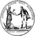
Wayne Medal Front
"Gold medal awarded by Congress to General Wayne. This is a representation of the medal, the size of…
Wayne Medal Back
"Gold medal awarded by Congress to General Wayne. This is a representation of the medal, the size of…
Sticklebacks and Nest
"A few fish, however, form a sort of nest for the protection of their eggs and young; and in some instances,…
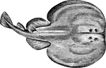
Electric Ray
"It is remarkable for an electric battery situated between the pectorals and head and gills; this is…
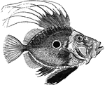
John Doree
"Average weight five pounds; found on the European coasts, and celebrated for the delicacy of its flesh.…
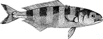
Pilotfish
"The pilot fish attains a length of about one foot. It is somewhat of the mackerel form, of a silver-gray…
Shanny
"A very curious species, five sinches long, remarkable for creeping out of the water with their pectoral…
Anchovy
"A small silvery fish, four or five inches long; it is taken in vast numbers i nthe Mediterranean, where…
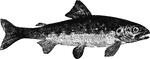
Parr
"Found in European waters, and being marked on the back by transverse dusky bars very similar to those…
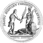
Stewart Medal Front
"Medal awarded to Major Stewart. This represents the medal the size of the original. The device is America…
Stewart Medal Back
"Medal awarded to Major Stewart. This represents the medal the size of the original. On the back side…
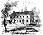
Jameson's Head-quarters
"Colonel Jameson's head-quarters. This is a view of the out-buildings of Mr. Sands, at North Castle,…
Sleepy Hollow Church
"Ancient Dutch Church in Sleepy Hollow. This view is from the church-yard, looking southwest. The porch…
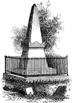
Van Wart's Monument
"Van Wart's monument. The following are the inscriptions upon this monument: North Side: 'Here repose…
Sunnyside
"View of 'Sunnyside,' the residence of Washington Irving. Built by Wolfert Ecker and known famously…
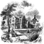
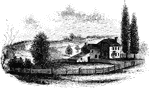
Livingston Mansion
"The Livingston Mansion. This is a view from the lawn on the north side. It is embowerd in trees and…
Tappan head-quarters
"Washington's head-quarters at Tappan. This view is from the yard, near the well. The date of its erection…
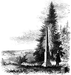
Torn Rock
"Torn Rock. This view is from the verge of the dam above the Ramapo works, near the rail-way, looking…
Ramapo Pass
"Remains of intrenchments the Ramapo Pass. This view is from the road, looking north toward the village…
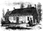
Hopper House
"The Hopper House. This view is from the road, looking northeast. The low part, on the left, is a portion…
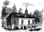
Friends' meeting-house
"Friends' meeting-house. This view is from the shed in the yard, looking southeast. The building stands…
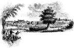
Trenton
"Trenton Bridge and vicinity. This view is from the north side of the Assanpink, a few rods above the…
Princeton battle-ground
"View of the battle-ground near Princeton. This view, looking north, is from the carriage gate of Mr.…
Red Bank Monument
"Monument at Red Bank. This view includes the monument, a portion of the Delaware, and the mouth of…
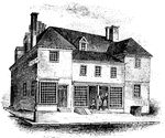
Penn's House
"Penn's House. This view is from Second Street. The building is of imported brick, except the modern…
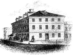
Walnut Street Prison
"The Walnut Street Prison. This edifice was erected in 1774, and taken down in 1836. The beautiful new…
Washington's head-quarters
"Washington's head-quarters. This view is from the Reading rail-road, looking east, and includes a portion…
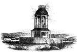
Observatory
"The observatory. This view is from the field, looking north. On the left is seen the winding Schuylkill,…
Monmouth Battle-Ground
"Battle-ground at Monmouth. This view is from the orchard, upon the site of Wayne's position when Monckton…
Jefferis' Ford
"View at Jefferis' Ford. This view is from the easterly bank of the Brandywine. The ford was at the…
Birmingham Meeting-House
"Birmingham Meeting-house. This is a view of the southerly front of the meeting-house. The building…
Chad's Ford
"View at Chad's Ford. This view is from the east bank of the Brandywine, looking southwest. The ford…
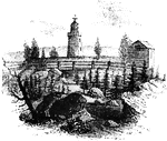
Congress House
"The Congress House. This view is from Baltimore Street, looking southeast. The ront on the left is…
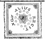
Pulaski's Banner Back
"Pulaski's Banner. On the other side, in the center, is the All-seeing Eye, with the words Non Alius…
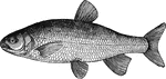
Chub
"Frequents deep places in the quiet parts of steams, sheltering itself usually under a bush or tree…
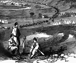
Strasburg Lookout
"View of the town of Strasburg, valley of the Shenandoah, occupied by the Federal forces under General…
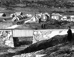
Bridge at Strasburg
"View of the town of Strasburg, valley of the Shenandoah, occupied by the Federal forces under General…
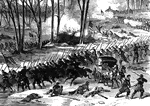
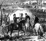
Battle of Stone River
"Battle of Stone River, Tenn. The decisive charge of General Negley's division across the river- the…
Battle of Stone River
"Battle of Stone River, Tenn. The decisive charge of General Negley's division across the river- the…
Battle of Stone River
"Battle of Stone River, Tenn. The decisive charge of General Negley's division across the river- the…
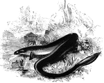
Common European Eel
"These have an elongated form, and a soft, thick, slimy skin; the scales are very minute, and imbedded…
Battle of Pea Ridge
"Battle of Pea Ridge, Ark., fought March 6th, 7th and 8th, 1862, between the Federal forces, 13,000…
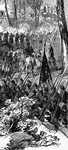
Battle of Pea Ridge
"Battle of Pea Ridge, Ark., fought March 6th, 7th and 8th, 1862, between the Federal forces, 13,000…
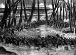
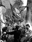
Battle of Munfordville
"Battle of Munfordville, Ky., Sunday, September 14th, 1862- the Confederates charging through the abatis…
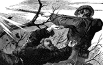
Battle of Munfordville
"Battle of Munfordville, Ky., Sunday, September 14th, 1862- the Confederates charging through the abatis…
Battle of Munfordville
"Battle of Munfordville, Ky., Sunday, September 14th, 1862- the Confederates charging through the abatis…
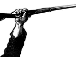
Hand with Gun
"Picture of a hand with a gun at the Battle of Munfordville, Ky., Sunday, September 14th, 1862- the…
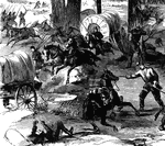
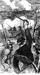
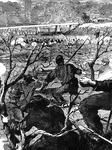
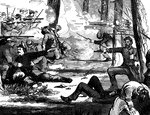
Attack at Harrisonburg
"Gallant attack by 150 of the Pennsylvania Bucktails, led by Colonel Kane, upon a portion of General…
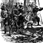
Attack at Harrisonburg
"Gallant attack by 150 of the Pennsylvania Bucktails, led by Colonel Kane, upon a portion of General…
Attack at Harrisonburg
"Gallant attack by 150 of the Pennsylvania Bucktails, led by Colonel Kane, upon a portion of General…