Officer's Tents
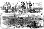
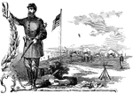
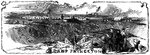
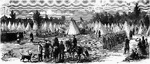
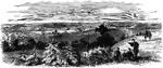
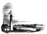
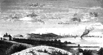
"New Jersey Camp at Arling, Va., designated as Camp Princeton in honor of one of the Revolutionary battle…
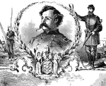
Theodore Runyon
"New Jersey Camp at Arling, Va., designated as Camp Princeton in honor of one of the Revolutionary battle…
Aid-de-camp
"New Jersey Camp at Arling, Va., designated as Camp Princeton in honor of one of the Revolutionary battle…
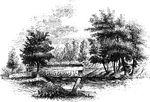
Camp Princeton
"New Jersey Camp at Arling, Va., designated as Camp Princeton in honor of one of the Revolutionary battle…
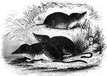
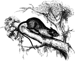
Shrews
"Is about the size of a rat.. Their legs are of equal length, and terminate into five toes, which are…
Zouaves
"Encampment of Colonel Ellsworth's New York Fire Zuoaves, on the heights opposite the Navy Yard, Washington,…
Columbus, Kentucky
"General view of Columbus, Ky., and its fortications, looking down the river, showing the 'Iron Bluffs'…
Confederate Batteries
"Fredericksburg, Va., and the Confederate batteries and pickets, as seen from Falmouth Heights, headquarters…
Fort Moultrie
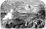
"Siege of Charleston, S. C. Bombardment of Fort Moultrie and Batteries Bee and Beauregard by the monitors…
Howlett's Battery
"Howlett's Confederate Battery on the James River, Va., shelling the Federal monitors and laborers on…
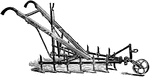
Iron Age horse Cultivator
An Iron Age horse cultivator, good for working crops which require a horse cultivator. The levers can…
Free Mouse
Dendromys Typicus. "Size of the common mice, and are of a pearly-gray color, and have a black band running…
Battle-ground
This view is taken from near the house of Mr. Neilson, looking northwest. In the foreground, on the…
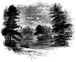
Bloody Run
Bloody Run, a stream which comes leaping in sparkling cascades from the hills, and affords fine trout…
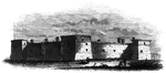
Western Line of Barracks
Western line of barracks. There were four large buildings used for barracks within the fort, the walls…
Arnold's Battle
Scene of Arnold's naval battle. This sketch was made from the pilot's room of the steam-boat just after…
Fort at Chambly
Fort at Chambly, this is a view of the south and west sides of the fort, looking toward the river. It…
Arnold Wounded
Place where Arnold was wounded. This view is in a narrow alley near the north end of Sault au Matelot…
Fort Niagra
Distant view of Fort Niagra. This view is from the west side of the Niagra River, near the light-house.…
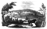
Oriskany
The battle-ground of Oriskany. This sketch was made from the eastern side of the ravine, looking west.…
Monocasy Island
The Susquehanna at Monocasy Island. This view is from the left of eastern bank of the Susquehanna, opposite…
Bennington Battle-ground
The Bennington battle-ground. This view is from the hill on the southwest bank of the Walloomscoick,…
Ridgefield
Place of the barricade, Ridgefield. This view is at the north end of the main street. It was taken from…
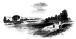
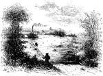
Fitch's Point
Fitch's Point, the landing-place of the British. This view is from the west side of Gregory's Point,…
Arnold's residence
Arnold's residence. Arnold lived in Water Street, near the ship-yard. The house is still standing (1848),…
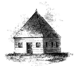
First Meeting House
First meeting hall. This picture of the first house for Christian worship erected in Connecticut is…
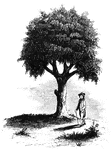
Liberty Tree
"Liberty Tree. I am indebted to the Hon. David Sears, of Boston, for this sketch of the 'Liberty Tree,'…
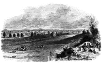
Boston
"View of Boston from Dorchester Heights in 1774. This picture is from an English print of the time.…
Skirmish at Lexington
"Skirmish at Lexington. The largest building in the picture is the meeting-house, and the officer on…
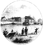
New London Harbor
"New London Harbor, looking north. This little sketch shows the relative position of the forts. Fort…
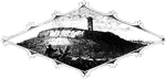
Tonomy Hill
"Top of Tonomy Hill. This view is from the northside of the hill, looking south. The wall appearance…
Prescott's Headquarters
"Prescott's Headquarters. This house is on the east side of the west road, about a mile from the bay.…
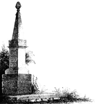
Goshen Monument
"Monument at Goshen. During the battle, Major Wood, of Goshen, made a masonic sign, by accident, which…

Mrs. Falls'
"Mrs. Falls'. This house, now (1850) owned by Mr. Samuel Moore, is a frame building, and stands on the…
Fort Montgomery
"View near Fort Montgomery. This view is from an eminence near the mountain road, about three quarters…
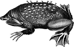
Surinam toad
"At the breeding season the back of the female exhbits a number of small pits; into these pits the male…
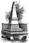
Van Wart's Monument
"Van Wart's monument. The following are the inscriptions upon this monument: North Side: 'Here repose…
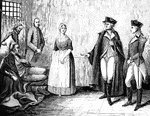
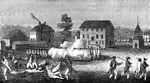
Colonel Rall
"Washington's visit to Colonel Rall. This is a copy, by permission, of a picture by Flagg, in the possession…
Trenton
"Trenton Bridge and vicinity. This view is from the north side of the Assanpink, a few rods above the…
Princeton battle-ground
"View of the battle-ground near Princeton. This view, looking north, is from the carriage gate of Mr.…
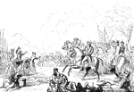
Monmouth
"The field of Monmouth. In the picture here given, the chief is seen most prominently on his white charger,…
Chad's Ford
"View at Chad's Ford. This view is from the east bank of the Brandywine, looking southwest. The ford…
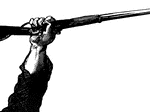
Hand with Gun
"Picture of a hand with a gun at the Battle of Munfordville, Ky., Sunday, September 14th, 1862- the…
Bastile Key
"Key of the Bastile. This key of the old Paris prison known as the Bastile, was sent by La Fayette to…
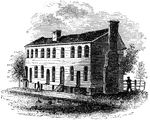
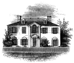
Old City Tavern
"Old City Tavern. This is a frame building, and stands on the northwest corner of Main and Nineteenth…
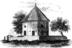
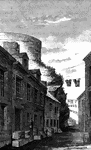
Old Magazine
"The Old Magazine. This view is from the square, looking southeast. South of it is a neat frame building,…
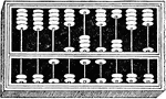
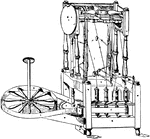
Abacus
"A tray strewn with dust or sand, used in ancient times for calculating. A contrivance for calculating,…
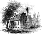
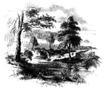
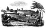
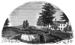
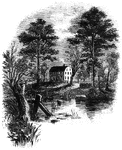
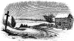
Moore's House
"This is a view from the lawn, looking south. It is a frame building with a brick foundation. At the…
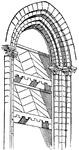
Abat-vent
"A vertical series of sloping roofs or broad slats, inclined outward and downward, forming the filling…

Regulator Battle-ground
"The Regulator battle-ground. This view is from the south side of the Salisbury Road, which is marked…
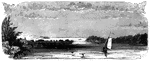
Trading Ford
"Trading Ford. This view of the Trading Ford, where greene, with Morgan and his light troops, crossed…
Guilford Battle-ground
"View of the battle-ground. This view is from the eminence southwest of the site of old Guilford Court…
Cherokee Ford
"View at the Cherokee Ford. This view is from the east bank of the river. Toward the extreme right is…